IMAGE CREDITED TO THE NATIONAL HURRICANE CENTRE
TROPICAL WAVE
A weak tropical wave continues to move across the Leeward Islands and the Virgin Islands this evening. This wave produced periods of passing showers today and has increased atmospheric moisture across the area. Forecasters think we could see some more passing showers overnight into tomorrow morning as this tropical wave continues to move across the area. Some showers could be locally heavy at times.
TROPICAL STORM DON
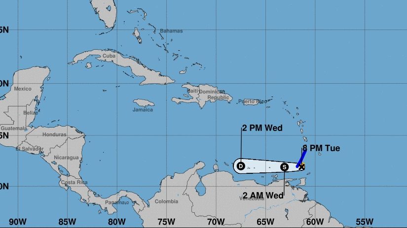
According to the National Hurricane Centre, at 800 PM, the centre of Tropical Storm Don was located near latitude 11.9 North, longitude 61.4 West. Don is moving toward the west near 23 mph. This general motion is expected through Wednesday. On the forecast track, the center of Don will move across the Windward Islands within the next few hours, and then move westward across the southeastern Caribbean Sea late tonight and Wednesday.
Maximum sustained winds are near 40 mph with higher gusts. Little change in strength is forecast during the next 24 hours.
Tropical-storm-force winds extend outward up to 35 miles from the centre. The estimated minimum central pressure is 1011 mb.
Air Force Reconnaissance data and satellite imagery indicate that Don may no longer have a closed low. It is still classified as a tropical storm by the National Hurricane Center at this time. It is possible that the system is weaker. Another reconnaissance mission is scheduled to investigate this evening. It is possible that Don will be downgraded to a tropical wave if the reconnaissance mission cannot find a closed low.
Don will continue to track quickly to the west as high pressure will remain well established to the north of the storm. There is chance Don could be a tropical wave as it moves across the Caribbean on Wednesday and Thursday.
DISTURBANCE 1
Disturbance 1 is a well-defined area of low pressure is approximately 1765 miles ESE of the Virgin Islands. It is moving slowly to the northwest. At this time forecasters do not think it will affect the islands of the eastern Caribbean. While the surface low is well-defined, the squalls associated with the disturbance are not well organized. In addition, the environmental conditions are not that favorable for development. Forecasters assess that the chance of development remains 30 percent.
Please visit the DDM’s website and subscribe for updates at www.bviddm.com or join us on facebook at https://www.facebook.com/bvi.ddm/
Disclaimer: The Department of Disaster Management (DDM) is not an official Meteorological Office. The Information disseminated by the Department is gathered from a number of professional sources used or contracted by the DDM to provide such information. This information is to be used as a guide by anyone who has interest in local weather conditions. By no means can the DDM or the BVI Government be held accountable by anyone who uses this information appropriately for legal evidence or in justification of any decision which may result in the loss of finances, property or life.