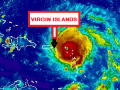
The center of Hurricane Irma has shifted and on this forecast track, the extremely dangerous core of Irma is forecast to pass approximately 5 miles off the Road Town area very soon.
At 1100 AM, the eye of Hurricane Irma was located near latitude 18.2 North, longitude 64.0 West. Irma is moving toward the west-northwest near 16 mph, and this general motion is expected to continue for the next couple of days.
Maximum sustained winds are near 185 mph with higher gusts. Hurricane-force winds extend outward up to 50 miles from the center and tropical-storm-force winds extend outward up to 185 miles. The estimated minimum central pressure is 918 mb.
The combination of a life-threatening storm surge and large breaking waves will raise water levels ABOVE NORMAL TIDE LEVELS within the hurricane warning area near and to the north of the center of Irma. Near the coast, the surge will be accompanied by large and destructive waves.
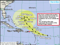
Rainfall amounts of 8 to 12 inches, isolated 20 inches are projected for the British Virgin Islands.
A Flash Flood Watch remains in effect for the Territory.
Please continue to monitor local media stations, DDM’s website (bviddm.com) and Facebook at BVIDDM for regular updates and preparedness tips.
Disclaimer: The Department of Disaster Management (DDM) is not an official Meteorological Office. The Information disseminated by the Department is gathered from a number of professional sources used or contracted by the DDM to provide such information. This information is to be used as a guide by anyone who has interest in local weather conditions. By no means can the DDM or the BVI Government be held accountable by anyone who uses this information appropriately for legal evidence or in justification of any decision which may result in the loss of finances, property or life