The Hurricane Hunter aircraft reports that Maria is intensifying and expected to become a major hurricane later today.
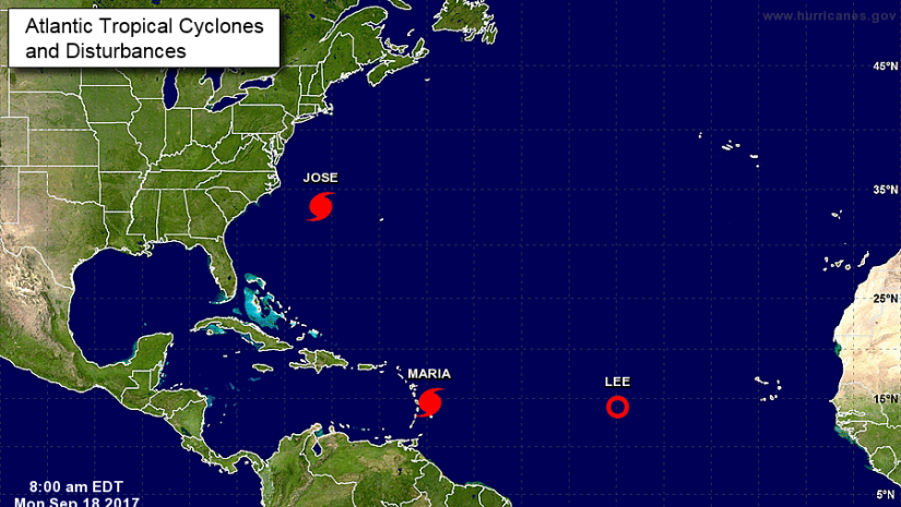
At 8:00 a.m., the center of Hurricane Maria was located near latitude 14.6 degree North, longitude 59.7 degrees West or about 120 miles east-southeast of Dominica. Maria is moving toward the west-northwest near 12 miles per hour (mph) and this motion, with a decrease in forward speed is expected through Tuesday night.
On the forecast track, the center of Maria will move across the Leeward Islands late today and tonight, and then over the extreme northeastern Caribbean Sea Tuesday and Tuesday night.
Reports from an Air Force Reserve Hurricane Hunter aircraft indicate that maximum sustained winds have increased to near 110 mph with higher gusts.
Maria is currently a Category 2 hurricane on the Saffir-Simpson Hurricane Wind Scale. Additional rapid strengthening is forecast during the next 48 hours, and Maria is expected to become a dangerous major hurricane before it moves through the Leeward Islands.
Hurricane-force winds extend outward up to 15 miles from the center and tropical-storm-force winds extend outward up to 105 miles (165 km).
The minimum central pressure estimated from the Hurricane Hunter aircraft data is 967 millibars.
A hurricane watch remains in effect for the BVI. A Hurricane Watch means that hurricane conditions are possible within the watch area. A watch is typically issued 48 hours before the anticipated first occurrence of tropical-storm-force winds, conditions that make outside preparations difficult or dangerous.
Hurricane conditions are first expected within portions of the Leeward Islands by late today, with tropical storm conditions beginning during the next several hours.
Hurricane conditions are possible within the hurricane watch area by Tuesday, with tropical storm conditions possible tonight.
Maria is expected to produce total rain accumulations of 6 to 12 inches with isolated maximum amounts of 20 inches across the British Virgin Islands.
Rainfall could cause life-threatening flash floods and mudslides.
Gusty winds could blow debris from Hurricane Irma around, creating dangerous conditions. Residents are therefore encouraged to secure all loose items in and around their homes.
Residents are also urged to monitor the movement of Maria closely.
Please continue to monitor local media stations, DDM’s website (bviddm.com) and Facebook at BVIDDM for regular updates.
Disclaimer: The Department of Disaster Management (DDM) is not an official Meteorological Office. The Information disseminated by the Department is gathered from a number of professional sources used or contracted by the DDM to provide such information. This information is to be used as a guide by anyone who has interest in local weather conditions. By no means can the DDM or the BVI Government be held accountable by anyone who uses this information appropriately for legal evidence or in justification of any decision which may result in the loss of finances, property or life.