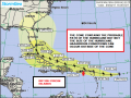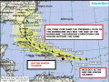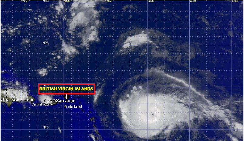
Hurricane Irma continues to strengthen as it approaches the Leewards and Virgin Islands.
In its 8:00 p.m. advisory, the National Hurricane Centre, said data from an Air Force Reserve Hurricane Hunter aircraft indicate that the maximum sustained winds have increased to near 140 miles per hour (mph) with higher gusts. Additional strengthening is forecast during the next 48 hours.
Hurricane-force winds extend outward up to 40 miles from the centre and tropical-storm-force winds extend outward up to 140 miles.
At 8:00p.m. Irma was located near latitude 16.7 degrees North, longitude 55 degrees West. The category 4 hurricane is moving towards the west near 13 mph and this general motion is expected to continue into Tuesday, followed by a turn toward the west-northwest late Tuesday.
On the forecast track, the center of Irma will move approximately 35 miles north east of the British Virgin Islands on Wednesday.
The latest minimum central pressure reported by reconnaissance aircraft is 943 millibars.
PROBABLE IMPACTS FOR ROAD TOWN
Wind
Winds 80 mph to 110 mph is possible in some locations with higher gusts at elevated areas and on the northern coast of Tortola as well as the northern islands including Anegada.
Rainfall
Rainfall amounts of 8 to 14 inches are likely and this would likely cause street flooding and travel delays. Mudslides are possible in the mountainous areas.
Storm Surge
With the track north of the British Virgin Islands, a storm surge of up to 6-8 feet will be possible on Tortola and increased up 10-14 feet for the northern islands including Anegada. This would result in damage to coastal structures.
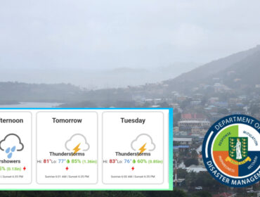
Please continue to monitor local media stations, DDM’s website (bviddm.com) and Facebook at BVIDDM for regular updates and preparedness tips.
Disclaimer: The Department of Disaster Management (DDM) is not an official Meteorological Office. The Information disseminated by the Department is gathered from a number of professional sources used or contracted by the DDM to provide such information. This information is to be used as a guide by anyone who has interest in local weather conditions. By no means can the DDM or the BVI Government be held accountable by anyone who uses this information appropriately for legal evidence or in justification of any decision which may result in the loss of finances, property or life.
photo credited to Stormgeo