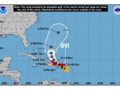
LOCATION…16.9N 65.5W
ABOUT 127 MI… South of British Virgin Islands
ABOUT 150 MI…165 KM SE OF PONCE PUERTO RICO
MAXIMUM SUSTAINED WINDS…65 MPH…100 KM/H
PRESENT MOVEMENT…WNW OR 285 DEGREES AT 8 MPH…13 KM/H
MINIMUM CENTRAL PRESSURE…994 MB…29.35 INCHES
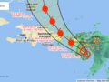
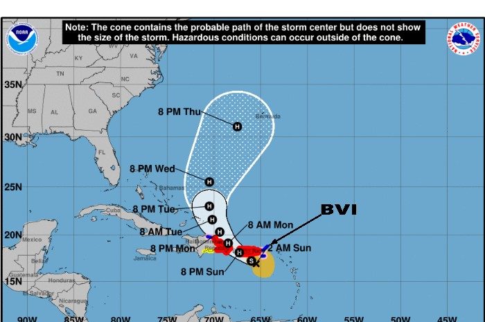
BASED ON THE LATEST FORECAST TRACK INFORMATION, TROPICAL STORM FIONA IS PASSING SOUTH OF THE BRITISH VIRGIN ISLANDS. THIS MEANS THAT THE BRITISH VIRGIN ISLANDS WILL BE EXPOSED TO TROPICAL STORM FORCE WINDS THROUGH TO SUNDAY.
MORE SPECIFIC IMPACTS INCLUDE:
WINDS: 30 TO 40 MPH SUSTAINED WINDS WITH POSSIBLE HIGHER GUSTS TO 55 MPH ARE LIKELY. THESE WINDY CONDITIONS COULD PRODUCE FLYING DEBRIS FROM SMALL OBJECTS AND DAMAGE TO WEAK INFRASTRUCTURE.
RAINFALL: RAINFALL ACCUMULATIONS OF 1 TO 4 INCHES ARE POSSIBLE OVER THE NEXT 24 HOURS. THIS COULD PRODUCE FLASH FLOODING IN LOW LYING AND FLOOD PRONE AREAS AS WELL AS MUDSLIDES.
SEAS: ALONG WITH STORM SURGE, SEAS COULD REACH UP TO 15 FEET WHICH COULD PRODUCE BATTERING WAVES AND RIP CURRENTS. AS A RESULT, MARINERS AND BEACH-GOERS SHOULD STAY IN PORT AND AVOID THE BEACHES.
RESIDENTS IN THE BRITISH VIRGIN ISLANDS SHOULD CONTINUE TO CLOSELY MONITOR THE PROGRESS OF FIONA.
At 200 AM AST (0600 UTC), the center of Tropical Storm Fiona was located near latitude 16.9 North, longitude 65.5 West. Fiona is moving toward the west-northwest near 8 mph (13 km/h). A northwestward motion is expected to begin later today and continue through Tuesday. On the forecast track, the center of Fiona will pass southwest of the U.S. Virgin Islands and approach Puerto Rico this morning, and then move near or over Puerto Rico this afternoon or evening. Fiona will then move near the northern coast of the Dominican Republic tonight and Monday, and near or to the east of the Turks and Caicos Islands on Tuesday.
Data from an Air Force Reserve Hurricane Hunter aircraft indicate that maximum sustained winds have increased to near 65 mph (100 km/h) with higher gusts. Strengthening is forecast, and Fiona is expected to become a hurricane before reaching the southern or southwestern coast of Puerto Rico later today. Additional strengthening is expected on Monday and Tuesday while Fiona moves over the southwestern Atlantic.
Tropical-storm-force winds extend outward up to 140 miles (220 km) from the center.
The latest minimum central pressure reported by the Hurricane Hunter aircraft is 994 mb (29.35 inches).
WIND: Hurricane conditions are expected on Puerto Rico today, and are expected in portions of the eastern Dominican Republic tonight and Monday. Hurricane conditions are possible in the U.S. Virgin Islands this morning. Hurricane conditions are possible within the hurricane watch area in the Dominican Republic tonight and Monday.
Tropical storm conditions are occurring in the U.S. and British Virgin Islands, and will spread westward across Puerto Rico this morning and across portions of the Dominican Republic later today. Tropical storm conditions are possible across the watch area in the Dominican Republic tonight.
𝐁𝐀𝐒𝐄𝐃 𝐎𝐍 𝐓𝐇𝐄 𝐌𝐎𝐕𝐄𝐌𝐄𝐍𝐓 𝐀𝐍𝐃 𝐃𝐄𝐕𝐄𝐋𝐎𝐏𝐌𝐄𝐍𝐓 𝐎𝐅 𝐅𝐈𝐎𝐍𝐀 𝐓𝐇𝐈𝐒 𝐈𝐍𝐅𝐎𝐑𝐌𝐀𝐓𝐈𝐎𝐍 𝐌𝐀𝐘 𝐂𝐇𝐀𝐍𝐆𝐄 𝐀𝐍𝐃 𝐅𝐔𝐑𝐓𝐇𝐄𝐑 𝐔𝐏𝐃𝐀𝐓𝐄𝐒 𝐖𝐈𝐋𝐋 𝐁𝐄 𝐏𝐎𝐒𝐓𝐄𝐃 𝐖𝐇𝐄𝐍 𝐍𝐄𝐂𝐄𝐒𝐒𝐀𝐑𝐘.
𝗖𝗼𝗻𝘁𝗶𝗻𝘂𝗲 𝘁𝗼 𝗰𝗵𝗲𝗰𝗸 𝘁𝗵𝗲 𝗗𝗗𝗠 𝗮𝗽𝗽, 𝗙𝗮𝗰𝗲𝗯𝗼𝗼𝗸, 𝗜𝗻𝘀𝘁𝗮𝗴𝗿𝗮𝗺, 𝗧𝘄𝗶𝘁𝘁𝗲𝗿 𝗽𝗮𝗴𝗲𝘀 𝗮𝗻𝗱 𝗼𝘂𝗿 𝘄𝗲𝗯𝘀𝗶𝘁𝗲 𝘄𝘄𝘄.𝗯𝘃𝗶𝗱𝗱𝗺.𝗰𝗼𝗺/ 𝗱𝗮𝗶𝗹𝘆 𝗳𝗼𝗿 𝘂𝗽𝗱𝗮𝘁𝗲𝘀.
𝘿𝙞𝙨𝙘𝙡𝙖𝙞𝙢𝙚𝙧: 𝙏𝙝𝙚 𝘿𝙚𝙥𝙖𝙧𝙩𝙢𝙚𝙣𝙩 𝙤𝙛 𝘿𝙞𝙨𝙖𝙨𝙩𝙚𝙧 𝙈𝙖𝙣𝙖𝙜𝙚𝙢𝙚𝙣𝙩 (𝘿𝘿𝙈) 𝙞𝙨 𝙣𝙤𝙩 𝙖𝙣 𝙤𝙛𝙛𝙞𝙘𝙞𝙖𝙡 𝙈𝙚𝙩𝙚𝙤𝙧𝙤𝙡𝙤𝙜𝙞𝙘𝙖𝙡 𝙊𝙛𝙛𝙞𝙘𝙚. 𝙏𝙝𝙚 𝙄𝙣𝙛𝙤𝙧𝙢𝙖𝙩𝙞𝙤𝙣 𝙙𝙞𝙨𝙨𝙚𝙢𝙞𝙣𝙖𝙩𝙚𝙙 𝙗𝙮 𝙩𝙝𝙚 𝘿𝙚𝙥𝙖𝙧𝙩𝙢𝙚𝙣𝙩 𝙞𝙨 𝙜𝙖𝙩𝙝𝙚𝙧𝙚𝙙 𝙛𝙧𝙤𝙢 𝙖 𝙣𝙪𝙢𝙗𝙚𝙧 𝙤𝙛 𝙥𝙧𝙤𝙛𝙚𝙨𝙨𝙞𝙤𝙣𝙖𝙡 𝙨𝙤𝙪𝙧𝙘𝙚𝙨 𝙪𝙨𝙚𝙙 𝙤𝙧 𝙘𝙤𝙣𝙩𝙧𝙖𝙘𝙩𝙚𝙙 𝙗𝙮 𝙩𝙝𝙚 𝘿𝘿𝙈 𝙩𝙤 𝙥𝙧𝙤𝙫𝙞𝙙𝙚 𝙨𝙪𝙘𝙝 𝙞𝙣𝙛𝙤𝙧𝙢𝙖𝙩𝙞𝙤𝙣. 𝙏𝙝𝙞𝙨 𝙞𝙣𝙛𝙤𝙧𝙢𝙖𝙩𝙞𝙤𝙣 𝙞𝙨 𝙩𝙤 𝙗𝙚 𝙪𝙨𝙚𝙙 𝙖𝙨 𝙖 𝙜𝙪𝙞𝙙𝙚 𝙗𝙮 𝙖𝙣𝙮𝙤𝙣𝙚 𝙬𝙝𝙤 𝙝𝙖𝙨 𝙞𝙣𝙩𝙚𝙧𝙚𝙨𝙩 𝙞𝙣 𝙡𝙤𝙘𝙖𝙡 𝙬𝙚𝙖𝙩𝙝𝙚𝙧 𝙘𝙤𝙣𝙙𝙞𝙩𝙞𝙤𝙣𝙨. 𝘽𝙮 𝙣𝙤 𝙢𝙚𝙖𝙣𝙨 𝙘𝙖𝙣 𝘿𝘿𝙈 𝙤𝙧 𝙩𝙝𝙚 𝘽𝙑𝙄 𝙂𝙤𝙫𝙚𝙧𝙣𝙢𝙚𝙣𝙩 𝙗𝙚 𝙝𝙚𝙡𝙙 𝙖𝙘𝙘𝙤𝙪𝙣𝙩𝙖𝙗𝙡𝙚 𝙗𝙮 𝙖𝙣𝙮𝙤𝙣𝙚 𝙬𝙝𝙤 𝙪𝙨𝙚𝙨 𝙩𝙝𝙞𝙨 𝙞𝙣𝙛𝙤𝙧𝙢𝙖𝙩𝙞𝙤𝙣 𝙖𝙥𝙥𝙧𝙤𝙥𝙧𝙞𝙖𝙩𝙚𝙡𝙮 𝙛𝙤𝙧 𝙡𝙚𝙜𝙖𝙡 𝙚𝙫𝙞𝙙𝙚𝙣𝙘𝙚 𝙤𝙧 𝙞𝙣 𝙟𝙪𝙨𝙩𝙞𝙛𝙞𝙘𝙖𝙩𝙞𝙤𝙣 𝙤𝙛 𝙖𝙣𝙮 𝙙𝙚𝙘𝙞𝙨𝙞𝙤𝙣 𝙬𝙝𝙞𝙘𝙝 𝙢𝙖𝙮 𝙧𝙚𝙨𝙪𝙡𝙩 𝙞𝙣 𝙩𝙝𝙚 𝙡𝙤𝙨𝙨 𝙤𝙛 𝙛𝙞𝙣𝙖𝙣𝙘𝙚𝙨, 𝙥𝙧𝙤𝙥𝙚𝙧𝙩𝙮 𝙤𝙧 𝙡𝙞𝙛𝙚.