SUMMARY OF 500 PM FRIDAY AUG 13TH 2021…INFORMATION
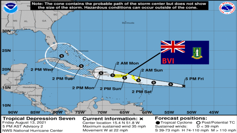
LOCATION…15.4N 51.8WABOUT 675 MILES…1085 KM E OF THE LEEWARD ISLANDS
ABOUT 742 MILES…1194 KM E OF ROAD TOWN
MAXIMUM SUSTAINED WINDS…35 MPH…55 KM/
HPRESENT MOVEMENT…W OR 275 DEGREES AT 22 MPH…35 KM/
HMINIMUM CENTRAL PRESSURE…1010 MB…29.83 INCHES
WATCHES AND WARNINGS——————–CHANGES WITH THIS ADVISORY:
𝐀 𝐓𝐫𝐨𝐩𝐢𝐜𝐚𝐥 𝐒𝐭𝐨𝐫𝐦 𝐖𝐚𝐭𝐜𝐡 𝐡𝐚𝐬 𝐛𝐞𝐞𝐧 𝐢𝐬𝐬𝐮𝐞𝐝 𝐟𝐨𝐫 𝐭𝐡𝐞 𝐔.𝐒. 𝐕𝐢𝐫𝐠𝐢𝐧 𝐈𝐬𝐥𝐚𝐧𝐝𝐬 .𝐚𝐧𝐝 𝐏𝐮𝐞𝐫𝐭𝐨 𝐑𝐢𝐜𝐨, 𝐢𝐧𝐜𝐥𝐮𝐝𝐢𝐧𝐠 𝐕𝐢𝐞𝐪𝐮𝐞𝐬 𝐚𝐧𝐝 𝐂𝐮𝐥𝐞𝐛𝐫𝐚. 𝐓𝐡𝐞 𝐠𝐨𝐯𝐞𝐫𝐧𝐦𝐞𝐧𝐭 𝐨𝐟 𝐀𝐧𝐭𝐢𝐠𝐮𝐚 𝐚𝐧𝐝 𝐁𝐚𝐫𝐛𝐮𝐝𝐚 𝐡𝐚𝐬 𝐢𝐬𝐬𝐮𝐞𝐝 𝐚 𝐓𝐫𝐨𝐩𝐢𝐜𝐚𝐥 𝐒𝐭𝐨𝐫𝐦 𝐖𝐚𝐭𝐜𝐡 𝐟𝐨𝐫 𝐀𝐧𝐠𝐮𝐢𝐥𝐥𝐚 𝐚𝐧𝐝 𝐭𝐡𝐞 𝐁𝐫𝐢𝐭𝐢𝐬𝐡 𝐕𝐢𝐫𝐠𝐢𝐧 𝐈𝐬𝐥𝐚𝐧𝐝𝐬.
The government of France has issued a Tropical Storm Watch for St. Martin and St. Barthelemy. The government of Sint Maarten has issued a Tropical Storm Watch for Sint Maarten.
SUMMARY OF WATCHES AND WARNINGS IN EFFECT:
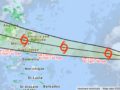
A Tropical Storm Watch is in effect for…* Antigua and Barbuda, Anguilla, St. Kitts and Nevis, and Montserrat* Saba and Sint Eustatius* Sint Maarten* St. Martin and St. Barthelemy* 𝐁𝐫𝐢𝐭𝐢𝐬𝐡 𝐕𝐢𝐫𝐠𝐢𝐧 𝐈𝐬𝐥𝐚𝐧𝐝𝐬* U.S. Virgin Islands* Puerto Rico, including Vieques and Culebra
𝐀 𝐓𝐫𝐨𝐩𝐢𝐜𝐚𝐥 𝐒𝐭𝐨𝐫𝐦 𝐖𝐚𝐭𝐜𝐡 𝐦𝐞𝐚𝐧𝐬 𝐭𝐡𝐚𝐭 𝐭𝐫𝐨𝐩𝐢𝐜𝐚𝐥 𝐬𝐭𝐨𝐫𝐦 𝐜𝐨𝐧𝐝𝐢𝐭𝐢𝐨𝐧𝐬 𝐚𝐫𝐞 𝐩𝐨𝐬𝐬𝐢𝐛𝐥𝐞 𝐰𝐢𝐭𝐡𝐢𝐧 𝐭𝐡𝐞 𝐰𝐚𝐭𝐜𝐡 𝐚𝐫𝐞𝐚, 𝐠𝐞𝐧𝐞𝐫𝐚𝐥𝐥𝐲 𝐰𝐢𝐭𝐡𝐢𝐧 𝟒𝟖 𝐡𝐨𝐮𝐫𝐬.
Interests elsewhere in the Leeward Islands, as well as the Dominican Republic, should monitor the progress of this system. Additional watches and warnings will likely be required for these areas tonight or on Saturday.
DISCUSSION AND OUTLOOK———————-
At 500 PM AST (2100 UTC), the center of Tropical Depression Seven was located near latitude 15.4 North, longitude 51.8 West. The depression is moving toward the west near 22 mph (35 km/h). A motion toward the west or west-northwest with a gradual decrease in forward speed is expected during the next few days. On the forecast track, the center of the depression is forecast to move over the Leeward Islands Saturday night, over the Virgin Islands and Puerto Rico on Sunday, and then over the Dominican Republic on Monday.
Maximum sustained winds are near 35 mph (55 km/h) with higher gusts. Some strengthening is forecast during the next couple of days, and the depression is expected to become a tropical storm tonight or on Saturday.
The estimated minimum central pressure is 1010 mb (29.83 inches).
𝗖𝗼𝗻𝘁𝗶𝗻𝘂𝗲 𝘁𝗼 𝗰𝗵𝗲𝗰𝗸 𝘁𝗵𝗲 𝗗𝗗𝗠 𝗮𝗽𝗽, 𝗙𝗮𝗰𝗲𝗯𝗼𝗼𝗸, 𝗜𝗻𝘀𝘁𝗮𝗴𝗿𝗮𝗺, 𝗧𝘄𝗶𝘁𝘁𝗲𝗿 𝗽𝗮𝗴𝗲𝘀 𝗮𝗻𝗱 𝗼𝘂𝗿 𝘄𝗲𝗯𝘀𝗶𝘁𝗲 𝘄𝘄𝘄.𝗯𝘃𝗶𝗱𝗱𝗺.𝗰𝗼𝗺/ 𝗱𝗮𝗶𝗹𝘆 𝗳𝗼𝗿 𝘂𝗽𝗱𝗮𝘁𝗲𝘀.
𝘿𝙞𝙨𝙘𝙡𝙖𝙞𝙢𝙚𝙧: 𝙏𝙝𝙚 𝘿𝙚𝙥𝙖𝙧𝙩𝙢𝙚𝙣𝙩 𝙤𝙛 𝘿𝙞𝙨𝙖𝙨𝙩𝙚𝙧 𝙈𝙖𝙣𝙖𝙜𝙚𝙢𝙚𝙣𝙩 (𝘿𝘿𝙈) 𝙞𝙨 𝙣𝙤𝙩 𝙖𝙣 𝙤𝙛𝙛𝙞𝙘𝙞𝙖𝙡 𝙈𝙚𝙩𝙚𝙤𝙧𝙤𝙡𝙤𝙜𝙞𝙘𝙖𝙡 𝙊𝙛𝙛𝙞𝙘𝙚. 𝙏𝙝𝙚 𝙄𝙣𝙛𝙤𝙧𝙢𝙖𝙩𝙞𝙤𝙣 𝙙𝙞𝙨𝙨𝙚𝙢𝙞𝙣𝙖𝙩𝙚𝙙 𝙗𝙮 𝙩𝙝𝙚 𝘿𝙚𝙥𝙖𝙧𝙩𝙢𝙚𝙣𝙩 𝙞𝙨 𝙜𝙖𝙩𝙝𝙚𝙧𝙚𝙙 𝙛𝙧𝙤𝙢 𝙖 𝙣𝙪𝙢𝙗𝙚𝙧 𝙤𝙛 𝙥𝙧𝙤𝙛𝙚𝙨𝙨𝙞𝙤𝙣𝙖𝙡 𝙨𝙤𝙪𝙧𝙘𝙚𝙨 𝙪𝙨𝙚𝙙 𝙤𝙧 𝙘𝙤𝙣𝙩𝙧𝙖𝙘𝙩𝙚𝙙 𝙗𝙮 𝙩𝙝𝙚 𝘿𝘿𝙈 𝙩𝙤 𝙞𝙢𝙥𝙧𝙤𝙫𝙞𝙙𝙚 𝙨𝙪𝙘𝙝 𝙞𝙣𝙛𝙤𝙧𝙢𝙖𝙩𝙞𝙤𝙣. 𝙏𝙝𝙞𝙨 𝙞𝙣𝙛𝙤𝙧𝙢𝙖𝙩𝙞𝙤𝙣 𝙞𝙨 𝙩𝙤 𝙗𝙚 𝙪𝙨𝙚𝙙 𝙖𝙨 𝙖 𝙜𝙪𝙞𝙙𝙚 𝙗𝙮 𝙖𝙣𝙮𝙤𝙣𝙚 𝙬𝙝𝙤 𝙝𝙖𝙨 𝙞𝙣𝙩𝙚𝙧𝙚𝙨𝙩 𝙞𝙣 𝙡𝙤𝙘𝙖𝙡 𝙬𝙚𝙖𝙩𝙝𝙚𝙧 𝙘𝙤𝙣𝙙𝙞𝙩𝙞𝙤𝙣𝙨. 𝘽𝙮 𝙣𝙤 𝙢𝙚𝙖𝙣𝙨 𝙘𝙖𝙣 𝘿𝘿𝙈 𝙤𝙧 𝙩𝙝𝙚 𝘽𝙑𝙄 𝙂𝙤𝙫𝙚𝙧𝙣𝙢𝙚𝙣𝙩 𝙗𝙚 𝙝𝙚𝙡𝙙 𝙖𝙘𝙘𝙤𝙪𝙣𝙩𝙖𝙗𝙡𝙚 𝙗𝙮 𝙖𝙣𝙮𝙤𝙣𝙚 𝙬𝙝𝙤 𝙪𝙨𝙚𝙨 𝙩𝙝𝙞𝙨 𝙞𝙣𝙛𝙤𝙧𝙢𝙖𝙩𝙞𝙤𝙣 𝙖𝙥𝙥𝙧𝙤𝙥𝙧𝙞𝙖𝙩𝙚𝙡𝙮 𝙛𝙤𝙧 𝙡𝙚𝙜𝙖𝙡 𝙚𝙫𝙞𝙙𝙚𝙣𝙘𝙚 𝙤𝙧 𝙞𝙣 𝙟𝙪𝙨𝙩𝙞𝙛𝙞𝙘𝙖𝙩𝙞𝙤𝙣 𝙤𝙛 𝙖𝙣𝙮 𝙙𝙚𝙘𝙞𝙨𝙞𝙤𝙣 𝙬𝙝𝙞𝙘𝙝 𝙢𝙖𝙮 𝙧𝙚𝙨𝙪𝙡𝙩 𝙞𝙣 𝙩𝙝𝙚 𝙡𝙤𝙨𝙨 𝙤𝙛 𝙛𝙞𝙣𝙖𝙣𝙘𝙚𝙨, 𝙥𝙧𝙤𝙥𝙚𝙧𝙩𝙮 𝙤𝙧 𝙡𝙞𝙛𝙚..