Hurricane Irma Summary
Current Location: 17.4 North / 50.3 West
Geographic Reference: 760 miles east of The Leeward Islands
Movement: West at 14 mph
Max Winds: 115 mph with higher gusts
Hurricane Force Winds from the centre: 35 miles
Current Radius of Tropical Storm-Force Winds: 140 miles
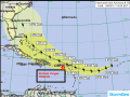
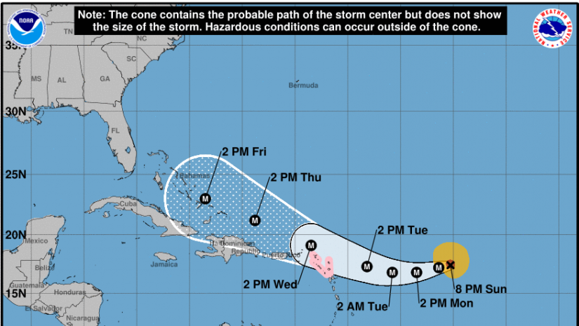
At 8:00 PM the National Hurricane Centre has indicated that the center of category 3 Hurricane Irma was located near latitude 17.4 North, longitude 50.3 West. Irma is moving toward the west near 14 mph. A westward to west-southwestward motion with some reduction in forward speed is expected through Monday night.
On the forecast track, the center of Irma is forecast to approach the northern Leeward Islands late Tuesday.
As a result hurricane watches are in effect for Antigua, Barbuda, Anguilla, Montserrat, St. Kitts, and Nevis, Saba, St. Eustatius, and Sint Maarten, Saint Martin and Saint Barthelemy.
A hurricane watch means hurricane conditions are possible within 48 hours.
Interests in the remainder of the Leeward Islands, the British and U.S. Virgin Islands, and Puerto Rico should monitor the progress of Irma. Additional Hurricane and Tropical Storm Watches may be required for portions of this area on Monday.
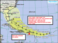
Irma will pass very close or over the northern Leeward Islands on Wednesday. The first squalls and tropical storm force winds are expected to reach the islands late on Tuesday. It could move near or over the British Virgin Islands Wednesday afternoon or evening. The track has also been shifted closer to Puerto Rico.
Maximum sustained winds are near 115 mph (185 km/h) with higher gusts. Irma is a category 3 hurricane on the Saffir-Simpson Hurricane Wind Scale. Some strengthening is forecast during the next 48 hours.
Hurricane-force winds extend outward up to 35 miles (55 km) from the center and tropical-storm-force winds extend outward up to 140 miles (220 km). The estimated minimum central pressure is 959 mb.
Based on the current forecast track, the eye of Hurricane Irma is expected to pass approximately 70 miles north east of the British Virgin Islands.
Irma is however moving over warm waters, and the environment is generally favorable for intensification. Irma is therefore forecast to intensify into a category 4 hurricane by the time it passes near or over the Leeward Islands. Afterward, Irma is expected to remain a powerful hurricane with some fluctuations in the intensity due to natural processes.
IMAGE CREDITED TO THE NATIONAL HURRICANE CENTRE
Please continue to monitor local media stations, DDM’s website (bviddm.com) and Facebook at BVIDDM for regular updates and preparedness tips.
Disclaimer: The Department of Disaster Management (DDM) is not an official Meteorological Office. The Information disseminated by the Department is gathered from a number of professional sources used or contracted by the DDM to provide such information. This information is to be used as a guide by anyone who has interest in local weather conditions. By no means can the DDM or the BVI Government be held accountable by anyone who uses this information appropriately for legal evidence or in justification of any decision which may result in the loss of finances, property or life.