WHCA31 TAPA
HURRICANE SAM ALERT STATEMENT
ANTIGUA AND BARBUDA METEOROLOGICAL SERVICES
5:04 PM ECT SUN, SEP 26, 2021
𝐀 𝐭𝐫𝐨𝐩𝐢𝐜𝐚𝐥 𝐜𝐲𝐜𝐥𝐨𝐧𝐞 𝐚𝐥𝐞𝐫𝐭 𝐫𝐞𝐦𝐚𝐢𝐧𝐬 𝐢𝐧 𝐞𝐟𝐟𝐞𝐜𝐭 𝐟𝐨𝐫 𝐭𝐡𝐞 𝐋𝐞𝐞𝐰𝐚𝐫𝐝 𝐈𝐬𝐥𝐚𝐧𝐝𝐬 𝐚𝐧𝐝 𝐭𝐡𝐞 𝐁𝐫𝐢𝐭𝐢𝐬𝐡 𝐕𝐢𝐫𝐠𝐢𝐧 𝐈𝐬𝐥𝐚𝐧𝐝𝐬. 𝐀 𝐭𝐫𝐨𝐩𝐢𝐜𝐚𝐥 𝐜𝐲𝐜𝐥𝐨𝐧𝐞 𝐚𝐥𝐞𝐫𝐭 𝐦𝐞𝐚𝐧𝐬 𝐭𝐡𝐚𝐭, 𝐢𝐧 𝐭𝐡𝐢𝐬 𝐜𝐚𝐬𝐞, 𝐚 𝐡𝐮𝐫𝐫𝐢𝐜𝐚𝐧𝐞 𝐢𝐬 𝐢𝐧 𝐨𝐮𝐫 𝐦𝐨𝐧𝐢𝐭𝐨𝐫𝐞𝐝 𝐚𝐫𝐞𝐚. 𝐖𝐚𝐭𝐜𝐡𝐞𝐬 𝐚𝐧𝐝 𝐰𝐚𝐫𝐧𝐢𝐧𝐠𝐬 𝐚𝐫𝐞 𝐧𝐨𝐭 𝐫𝐞𝐪𝐮𝐢𝐫𝐞𝐝 𝐚𝐭 𝐭𝐡𝐢𝐬 𝐭𝐢𝐦𝐞 𝐛𝐮𝐭 𝐦𝐚𝐲 𝐛𝐞 𝐧𝐞𝐜𝐞𝐬𝐬𝐚𝐫𝐲 𝐢𝐧 𝐭𝐡𝐞 𝐧𝐞𝐱𝐭 𝟕𝟐 𝐡𝐨𝐮𝐫𝐬.
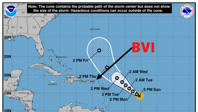
Based on current information and analysis, hurricane sam is expected to pass at a safe distance away from the Leeward Islands and British Virgin Islands with little or no wind impact to the islands. 𝐒𝐚𝐦 𝐢𝐬 𝐞𝐬𝐭𝐢𝐦𝐚𝐭𝐞𝐝 𝐭𝐨 𝐩𝐚𝐬𝐬 𝐛𝐞𝐭𝐰𝐞𝐞𝐧 𝟑𝟐𝟎-𝟑𝟑𝟎 𝐦𝐢𝐥𝐞𝐬 𝐞𝐚𝐬𝐭-𝐧𝐨𝐫𝐭𝐡𝐞𝐚𝐬𝐭 𝐨𝐟 𝐓𝐡𝐞 𝐁𝐕𝐈 𝐛𝐞𝐭𝐰𝐞𝐞𝐧 𝐖𝐞𝐝𝐧𝐞𝐬𝐝𝐚𝐲 𝐚𝐧𝐝 𝐓𝐡𝐮𝐫𝐬𝐝𝐚𝐲. 𝐀𝐬 𝐨𝐟 𝐭𝐡𝐞 𝟓 𝐩𝐦 𝐮𝐩𝐝𝐚𝐭𝐞 𝐭𝐨𝐝𝐚𝐲 𝐒𝐚𝐦 𝐢𝐬 𝐚𝐛𝐨𝐮𝐭 𝟗𝟎-𝟏𝟎𝟎 𝐦𝐢𝐥𝐞𝐬 𝐰𝐢𝐝𝐞 𝐭𝐡𝐞𝐫𝐞𝐟𝐨𝐫𝐞, 𝐭𝐡𝐞𝐫𝐞 𝐢𝐬 𝐚 𝐥𝐨𝐰 𝐭𝐡𝐫𝐞𝐚𝐭 𝐭𝐨 𝐭𝐡𝐞 𝐢𝐬𝐥𝐚𝐧𝐝𝐬 𝐰𝐢𝐭𝐡 𝐫𝐞𝐬𝐩𝐞𝐜𝐭 𝐭𝐨 𝐰𝐢𝐧𝐝𝐬.
However given the dynamic nature of Tropical Cyclones any shift to the south could bring the cyclone closer to the islands; hence residents should remain vigilant and keep close and continuous monitoring of this powerful and dangerous system.
As Sam passes, extensive impacts from swells/ surfs are expected to affect coastal areas which could lead to soil erosion and rip currents, therefore to be safe, residents will be asked to avoid these areas until the all clear is given.
At 500 pm ast (2100 utc), the center of hurricane Sam was located near latitude 14.2 north, longitude 50.5 west.
Sam is moving toward the northwest near 7 mph (11 km/h) and this motion is expected to continue for the next few days, along with a gradual increase in forward speed commencing by midweek.
Maximum sustained winds have increased to near 150 mph (240 km/h) with higher gusts. Sam is a category 4 hurricane on the saffir-simpson hurricane wind scale. Some fluctuations in intensity are expected during the next couple of days. Thereafter, some slow weakening is forecast.
Sam is a small tropical cyclone. Hurricane-force winds extend outward up to 30 miles (45 km) from the center and tropical-storm-force winds extend outward up to 90 miles (150 km).
The estimated minimum central pressure is 938 mb (27.70 inches).
𝗔𝘁 𝘁𝗵𝗶𝘀 𝘁𝗶𝗺𝗲 𝘁𝗵𝗲𝗿𝗲 𝗮𝗿𝗲 𝗻𝗼 𝘄𝗮𝘁𝗰𝗵𝗲𝘀 𝗼𝗿 𝘄𝗮𝗿𝗻𝗶𝗻𝗴𝘀 𝗳𝗼𝗿 𝘁𝗵𝗲 𝗕𝗿𝗶𝘁𝗶𝘀𝗵 𝗩𝗶𝗿𝗴𝗶𝗻 𝗜𝘀𝗹𝗮𝗻𝗱𝘀. 𝗣𝗲𝗿𝘀𝗼𝗻𝘀 𝗺𝘂𝘀𝘁 𝗰𝗼𝗻𝘁𝗶𝗻𝘂𝗲 𝘁𝗼 𝗺𝗼𝗻𝗶𝘁𝗼𝗿 𝘁𝗵𝗲 𝗔𝘁𝗹𝗮𝗻𝘁𝗶𝗰 𝗶𝗻 𝗰𝗮𝘀𝗲 𝗼𝗳 𝗮𝗻𝘆 𝗰𝗵𝗮𝗻𝗴𝗲𝘀 𝘄𝗶𝘁𝗵 𝘁𝗵𝗲 𝗵𝘂𝗿𝗿𝗶𝗰𝗮𝗻𝗲.
𝗖𝗼𝗻𝘁𝗶𝗻𝘂𝗲 𝘁𝗼 𝗰𝗵𝗲𝗰𝗸 𝘁𝗵𝗲 𝗗𝗗𝗠 𝗮𝗽𝗽 , 𝗙𝗮𝗰𝗲𝗯𝗼𝗼𝗸, 𝗜𝗻𝘀𝘁𝗮𝗴𝗿𝗮𝗺, 𝗧𝘄𝗶𝘁𝘁𝗲𝗿 𝗽𝗮𝗴𝗲𝘀 𝗮𝗻𝗱 𝗼𝘂𝗿 𝘄𝗲𝗯𝘀𝗶𝘁𝗲 𝘄𝘄𝘄.𝗯𝘃𝗶𝗱𝗱𝗺.𝗰𝗼𝗺/ 𝗱𝗮𝗶𝗹𝘆 𝗳𝗼𝗿 𝘂𝗽𝗱𝗮𝘁𝗲𝘀.
𝘿𝙞𝙨𝙘𝙡𝙖𝙞𝙢𝙚𝙧: 𝙏𝙝𝙚 𝘿𝙚𝙥𝙖𝙧𝙩𝙢𝙚𝙣𝙩 𝙤𝙛 𝘿𝙞𝙨𝙖𝙨𝙩𝙚𝙧 𝙈𝙖𝙣𝙖𝙜𝙚𝙢𝙚𝙣𝙩 (𝘿𝘿𝙈) 𝙞𝙨 𝙣𝙤𝙩 𝙖𝙣 𝙤𝙛𝙛𝙞𝙘𝙞𝙖𝙡 𝙈𝙚𝙩𝙚𝙤𝙧𝙤𝙡𝙤𝙜𝙞𝙘𝙖𝙡 𝙊𝙛𝙛𝙞𝙘𝙚. 𝙏𝙝𝙚 𝙄𝙣𝙛𝙤𝙧𝙢𝙖𝙩𝙞𝙤𝙣 𝙙𝙞𝙨𝙨𝙚𝙢𝙞𝙣𝙖𝙩𝙚𝙙 𝙗𝙮 𝙩𝙝𝙚 𝘿𝙚𝙥𝙖𝙧𝙩𝙢𝙚𝙣𝙩 𝙞𝙨 𝙜𝙖𝙩𝙝𝙚𝙧𝙚𝙙 𝙛𝙧𝙤𝙢 𝙖 𝙣𝙪𝙢𝙗𝙚𝙧 𝙤𝙛 𝙥𝙧𝙤𝙛𝙚𝙨𝙨𝙞𝙤𝙣𝙖𝙡 𝙨𝙤𝙪𝙧𝙘𝙚𝙨 𝙪𝙨𝙚𝙙 𝙤𝙧 𝙘𝙤𝙣𝙩𝙧𝙖𝙘𝙩𝙚𝙙 𝙗𝙮 𝙩𝙝𝙚 𝘿𝘿𝙈 𝙩𝙤 𝙞𝙢𝙥𝙧𝙤𝙫𝙞𝙙𝙚 𝙨𝙪𝙘𝙝 𝙞𝙣𝙛𝙤𝙧𝙢𝙖𝙩𝙞𝙤𝙣. 𝙏𝙝𝙞𝙨 𝙞𝙣𝙛𝙤𝙧𝙢𝙖𝙩𝙞𝙤𝙣 𝙞𝙨 𝙩𝙤 𝙗𝙚 𝙪𝙨𝙚𝙙 𝙖𝙨 𝙖 𝙜𝙪𝙞𝙙𝙚 𝙗𝙮 𝙖𝙣𝙮𝙤𝙣𝙚 𝙬𝙝𝙤 𝙝𝙖𝙨 𝙞𝙣𝙩𝙚𝙧𝙚𝙨𝙩 𝙞𝙣 𝙡𝙤𝙘𝙖𝙡 𝙬𝙚𝙖𝙩𝙝𝙚𝙧 𝙘𝙤𝙣𝙙𝙞𝙩𝙞𝙤𝙣𝙨. 𝘽𝙮 𝙣𝙤 𝙢𝙚𝙖𝙣𝙨 𝙘𝙖𝙣 𝘿𝘿𝙈 𝙤𝙧 𝙩𝙝𝙚 𝘽𝙑𝙄 𝙂𝙤𝙫𝙚𝙧𝙣𝙢𝙚𝙣𝙩 𝙗𝙚 𝙝𝙚𝙡𝙙 𝙖𝙘𝙘𝙤𝙪𝙣𝙩𝙖𝙗𝙡𝙚 𝙗𝙮 𝙖𝙣𝙮𝙤𝙣𝙚 𝙬𝙝𝙤 𝙪𝙨𝙚𝙨 𝙩𝙝𝙞𝙨 𝙞𝙣𝙛𝙤𝙧𝙢𝙖𝙩𝙞𝙤𝙣 𝙖𝙥𝙥𝙧𝙤𝙥𝙧𝙞𝙖𝙩𝙚𝙡𝙮 𝙛𝙤𝙧 𝙡𝙚𝙜𝙖𝙡 𝙚𝙫𝙞𝙙𝙚𝙣𝙘𝙚 𝙤𝙧 𝙞𝙣 𝙟𝙪𝙨𝙩𝙞𝙛𝙞𝙘𝙖𝙩𝙞𝙤𝙣 𝙤𝙛 𝙖𝙣𝙮 𝙙𝙚𝙘𝙞𝙨𝙞𝙤𝙣 𝙬𝙝𝙞𝙘𝙝 𝙢𝙖𝙮 𝙧𝙚𝙨𝙪𝙡𝙩 𝙞𝙣 𝙩𝙝𝙚 𝙡𝙤𝙨𝙨 𝙤𝙛 𝙛𝙞𝙣𝙖𝙣𝙘𝙚𝙨, 𝙥𝙧𝙤𝙥𝙚𝙧𝙩𝙮 𝙤𝙧 𝙡𝙞𝙛𝙚..


