Forecasters Latto and Brown of the National Hurricane Centre 8am advisory.
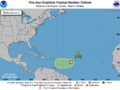
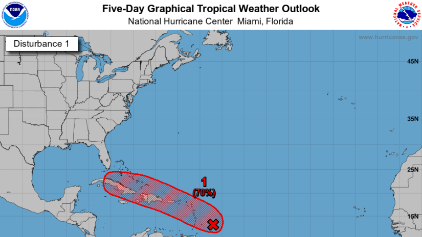
Showers and thunderstorms have become more concentrated this morning in association with a low pressure system located about 150 miles east of Barbados. Environmental conditions are expected to be conducive for additional development, and a tropical depression is likely to form later today or tonight while the low moves west-northwestward at 10 to 15 mph. The disturbance is forecast to reach portions of the Lesser Antilles tonight, then move near the Virgin Islands and Puerto Rico on Tuesday, and be near Hispaniola around the middle of this week. Tropical storm watches or warnings could be required today with shorter-than-normal lead times for portions of the Lesser Antilles, the Virgin Islands, and Puerto Rico. In addition, heavy rains and flooding are likely for the Leeward Islands, Virgin Islands, and Puerto Rico.
𝗔𝘁 𝘁𝗵𝗶𝘀 𝘁𝗶𝗺𝗲 𝘁𝗵𝗲𝗿𝗲 𝗮𝗿𝗲 𝗻𝗼 𝘄𝗮𝘁𝗰𝗵𝗲𝘀 𝗼𝗿 𝘄𝗮𝗿𝗻𝗶𝗻𝗴𝘀 𝗳𝗼𝗿 𝘁𝗵𝗲 𝗕𝗿𝗶𝘁𝗶𝘀𝗵 𝗩𝗶𝗿𝗴𝗶𝗻 𝗜𝘀𝗹𝗮𝗻𝗱𝘀. 𝗣𝗲𝗿𝘀𝗼𝗻𝘀 𝗺𝘂𝘀𝘁 𝗰𝗼𝗻𝘁𝗶𝗻𝘂𝗲 𝘁𝗼 𝗺𝗼𝗻𝗶𝘁𝗼𝗿 𝘁𝗵𝗲 𝗔𝘁𝗹𝗮𝗻𝘁𝗶𝗰 𝗶𝗻 𝗰𝗮𝘀𝗲 𝗼𝗳 𝗮𝗻𝘆 𝗰𝗵𝗮𝗻𝗴𝗲𝘀 𝘄𝗶𝘁𝗵 𝘁𝗵𝗲𝘀𝗲 𝘀𝘆𝘀𝘁𝗲𝗺𝘀.
𝗖𝗼𝗻𝘁𝗶𝗻𝘂𝗲 𝘁𝗼 𝗰𝗵𝗲𝗰𝗸 𝘁𝗵𝗲 𝗗𝗗𝗠 𝗮𝗽𝗽 , 𝗙𝗮𝗰𝗲𝗯𝗼𝗼𝗸, 𝗜𝗻𝘀𝘁𝗮𝗴𝗿𝗮𝗺, 𝗧𝘄𝗶𝘁𝘁𝗲𝗿 𝗽𝗮𝗴𝗲𝘀 𝗮𝗻𝗱 𝗼𝘂𝗿 𝘄𝗲𝗯𝘀𝗶𝘁𝗲 𝘄𝘄𝘄.𝗯𝘃𝗶𝗱𝗱𝗺.𝗰𝗼𝗺/ 𝗱𝗮𝗶𝗹𝘆 𝗳𝗼𝗿 𝘂𝗽𝗱𝗮𝘁𝗲𝘀.
Disclaimer: The Department of Disaster Management (DDM) is not an official Meteorological Office. The Information disseminated by the Department is gathered from a number of professional sources used or contracted by the DDM to provide such information. This information is to be used as a guide by anyone who has interest in local weather conditions. By no means can DDM or the BVI Government be held accountable by anyone who uses this information appropriately for legal evidence or in justification of any decision which may result in the loss of finances, property or life.