Image credited to the National Hurricane Centre
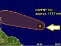
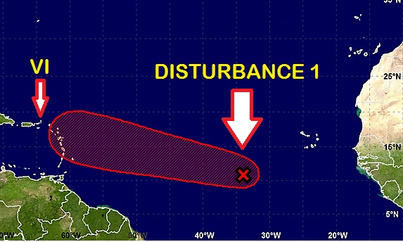
Disturbance 1(Invest 99L) was last noted near 9.9N 33.0W (approximately 2178 miles) and tracking west-northwest around 20mph. If the system continues at this present speed it could be in the vicinity of the Virgin Islands by the next 4 days. European guidance has begun to lower chances for this system to develop over the next 72 hours, though American GFS guidance remains more aggressive. Wind shear is conducive for development as it moves west. By 72 hours, this feature will approach the Lesser Antilles. Beyond 72 hours, models are quick to weaken and dissipate the system as it moves through the Lesser Antilles and Hispaniola. A HIGH (80%) risk of development remains for the next 72 hours.
As both models have a level of uncertainty, residents are encouraged to monitor the system as it progresses. There is still a chance Disturbance 1 can develop into a tropical depression next week. Pay close attention to this system for any sudden changes and be prepared to take the necessary actions.
Please visit the DDM’s website and subscribe for updates at www.bviddm.com or join us on Facebook at https://www.facebook.com/bvi.ddm/
Disclaimer: The Department of Disaster Management (DDM) is not an official Meteorological Office. The Information disseminated by the Department is gathered from a number of professional sources used or contracted by the DDM to provide such information. This information is to be used as a guide by anyone who has interest in local weather conditions. By no means can the DDM or the BVI Government be held accountable by anyone who uses this information appropriately for legal evidence or in justification of any decision which may result in the loss of finances, property or life.