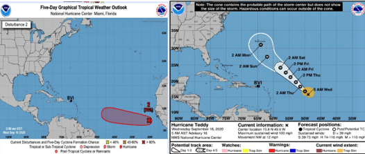
Images credited to the NHC
17th September 2020 – Disturbance 2 is located just off the west coast of Africa near 11N, 30W, or about 500 miles southwest of the Cabo Verde Islands. A general west-northwest track is expected over the next several days. It remains too early to determine whether or not it will make it as far west as the Caribbean. Impacts, if any, to the eastern Caribbean would not occur until over a week from now. Conditions remain marginally favorable and the risk of tropical development was reduced to 60 percent.
Hurricane Teddy is located about 650 miles east of the northern Leeward Islands with winds near 105 mph. Teddy is forecast to become a powerful hurricane as it passes well to the east and northeast of the BVI. Teddy will likely threaten Bermuda with hurricane conditions on Monday. High surf advisory has been issued for the British Virgin Islands until Sunday.
High surf advisory means that waves along the affected shores will be higher than normal. Residents and visitors are urged to avoid entering the water due to the dangerous wave action and strong rip currents.
Persons at home and abroad are encouraged to download the DDM’s Alert app in the Apple App store or Google Play store to receive updates of any hazards affecting the Territory.
You can also visit the DDM’s webpage at www.bviddm.com and subscribe for updates or like us on Facebook at www.facebook.com/bvi.ddm.
Disclaimer: The Department of Disaster Management (DDM) is not an official Meteorological Office. The Information disseminated by the Department is gathered from a number of professional sources used or contracted by the DDM to provide such information. This information is to be used as a guide by anyone who has interest in local weather conditions. By no means can the DDM or the BVI Government be held accountable by anyone who uses this information appropriately for legal evidence or in justification of any decision which may result in the loss of finances, property or life.


