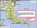
At 11:00 AM, the National Hurricane Centre indicated that Irma’s maximum sustained winds have increased yet again to 180 miles per hour with higher gusts.
At 1100 AM AST (1500 UTC), the eye of Hurricane Irma was located near latitude 16.8 North, longitude 58.4 West. Irma is moving toward the west near 14 mph (22 km/h), and this general motion is expected to continue today, followed by a turn toward the west-northwest tonight. On the forecast track, the extremely dangerous core of Irma is forecast to move over portions of the northern Leeward Islands tonight and early Wednesday. Hurricane-force winds extend outward up to 45 miles (75 km) from the center and tropical-storm-force winds extend outward up to 140 miles.
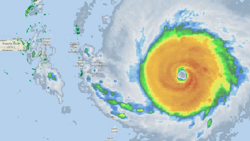
Reports from an Air Force Hurricane Hunter aircraft indicate that the maximum sustained winds are near 180 mph (285 km/h) with higher gusts. Irma is an extremely dangerous category 5 hurricane on the Saffir-Simpson Hurricane Wind Scale. Some fluctuations in intensity are likely during the next day or two, but Irma is forecast to remain a powerful category 4 or 5 hurricane during the next couple of days.
Hurricane-force winds extend outward up to 60 miles (95 km) from the center and tropical-storm-force winds extend outward up to 160 miles (260 km).
The latest minimum central pressure reported by reconnaissance aircraft is 931 mb (27.50 inches).
Hurricane Irma will move into the area today causing weather conditions to significantly deteriorate later this evening into tonight and tomorrow. Hurricane warning remains in effect the BVI.
A Hurricane Warning means that hurricane conditions are expected somewhere within the warning area. A warning is typically issued 36 hours before the anticipated first occurrence of tropical-storm-force winds, conditions that make outside preparations difficult or dangerous. In this case, for some of easternmost islands, the hurricane conditions are expected within the next 12 to 24 hours. Preparations to protect life and property should either be completed or rushed to completion.
Please continue to monitor local media stations, DDM’s website (bviddm.com) and Facebook at BVIDDM for regular updates and preparedness tips.
Disclaimer: The Department of Disaster Management (DDM) is not an official Meteorological Office. The Information disseminated by the Department is gathered from a number of professional sources used or contracted by the DDM to provide such information. This information is to be used as a guide by anyone who has interest in local weather conditions. By no means can the DDM or the BVI Government be held accountable by anyone who uses this information appropriately for legal evidence or in justification of any decision which may result in the loss of finances, property or life. Image Credit, National Hurricane Center.