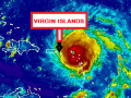
At 5:00 AM, the National Hurricane Centre has indicated that Hurricane Irma’s maximum sustained winds remain near 185 miles per hour (mph) with higher gusts.
Irma is the most powerful Atlantic hurricane in recorded history and will be the strongest system to ever make landfall in the Caribbean. The distinct eye of Hurricane Irma was located near latitude 17.9 degrees North, longitude 62.6 degrees West. Irma is moving toward the West North West near 16 mph
Hurricane-force winds extend outward up to 50 miles from the center and tropical-storm-force winds extend outward up to 175 miles. As Irma passed over Barbuda, wind gusts up to 155 mph were indicated before the recording instrument failed.
The estimated minimum central pressure is 916 millibars.
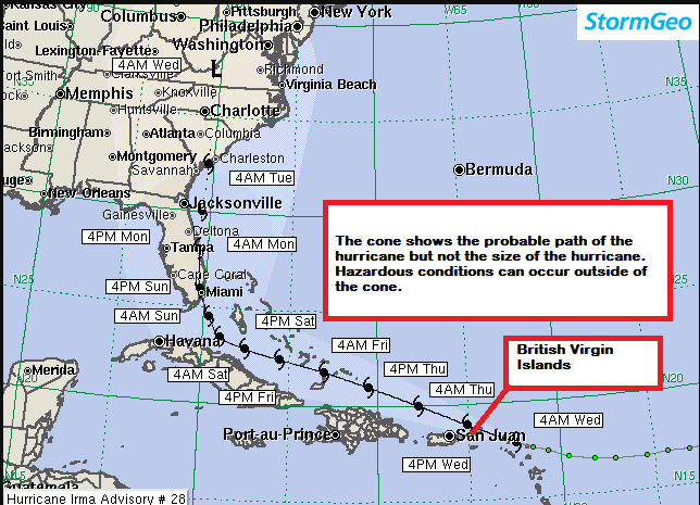
On the forecast track, the extremely dangerous core of Irma has moved over Barbuda and is currently over St. Martin and will move near or over portions of the northern Virgin Islands in the next few hours. Strong gusts are already being felt along the northern portion of the Territory causing effects on the electricity distribution feeders. Crews have commenced a systematic shut down of the electricity network to preserve the infrastructure. Residents are advised to unplug any electrical devices that are not being used.
Road Town, Tortola is located along latitude 18.25 degrees North, longitude 64.37 degrees West. Based on the latest forecasts, the approximate closest point of approach to Road Town from Hurricane Irma is 17 miles northeast. With the shift to the WNW, the centre of the hurricane is now expected to pass near or over the North South area of Virgin Gorda with winds extending throughout the entire Territory.
The Antigua and Barbuda Meteorological Services has indicated that sea conditions will be dangerously rough with swells of 20 feet during the passage of Irma. Small Craft operators should stay in Port and ensure that all vessels are safely moored and sea bathers should avoid waters.
Irma is expected to produce total rain accumulations of 8 to 14 inches with isolated maximum amounts of 15 inches across the British Virgin Islands. A Flash Flood Watch remains in effect for the Territory.
Please continue to monitor local media stations, DDM’s website (bviddm.com) and Facebook at BVIDDM for regular updates and preparedness tips.
Disclaimer: The Department of Disaster Management (DDM) is not an official Meteorological Office. The Information disseminated by the Department is gathered from a number of professional sources used or contracted by the DDM to provide such information. This information is to be used as a guide by anyone who has interest in local weather conditions. By no means can the DDM or the BVI Government be held accountable by anyone who uses this information appropriately for legal evidence or in justification of any decision which may result in the loss of finances, property or life