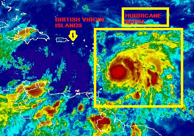
At 5:00 PM, the eye of Hurricane Maria was located near latitude 15.1 North, longitude 60.7 West. Maria is moving toward the west-northwest near 9 mph. On the forecast track, the center of Maria will move across Dominica in a few hours, approach the British Virgin Islands on Tuesday night and Wednesday.
Maximum sustained winds have increased to near 130 mph with higher gusts.
Hurricane-force winds extend outward up to 25 miles from the centre and tropical-storm-force winds extend outward up to 125 miles.
The minimum central pressure estimated from the Hurricane Hunter aircraft data is 950 mb.
Maria was still strengthening as the reconnaissance plane finished its mission a couple hours ago. Additional strengthening is likely over the next 24-36 hours By the time Maria reaches Puerto Rico Wednesday afternoon/evening, its wind field will be expanding due to eyewall replacement cycles. Hurricane force winds may extend out to 35 miles from the centre by then.
Forecasters take the centre of Maria into the eastern Caribbean this evening then across Puerto Rico on Wednesday night.
The centre is expected to pass approximately 67 miles south east of Road Town, Tortola however this may change as the system meanders closer.
By the time Maria makes landfall in Puerto Rico or just before it passes the British Virgin Islands, its winds may be as high as 150 mph, making it a strong Category 4 hurricane. Some weakening is expected by Thursday, due to interaction with Puerto Rico and the Dominican Republic.
Maria is expected to produce total rain accumulations of 10 to 15 inches with isolated maximum amounts of 20 inches in the British Virgin Islands through Wednesday night. Rainfall could cause life-threatening flash floods and mudslides.
On the present forecast wind conditions are expected to begin deteriorating on Tuesday afternoon.
A dangerous storm surge accompanied by large and destructive waves will raise water levels by as much as 6 to 9 feet above normal tide levels in the hurricane warning area near where the center of Maria moves across the Leeward Islands and the British Virgin Islands.
Please continue to monitor local media stations, DDM’s website (bviddm.com) and Facebook at BVIDDM for regular updates.
Disclaimer: The Department of Disaster Management (DDM) is not an official Meteorological Office. The Information disseminated by the Department is gathered from a number of professional sources used or contracted by the DDM to provide such information. This information is to be used as a guide by anyone who has interest in local weather conditions. By no means can the DDM or the BVI Government be held accountable by anyone who uses this information appropriately for legal evidence or in justification of any decision which may result in the loss of finances, property or life.


