DORIAN
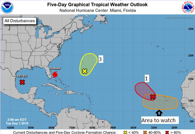
Dorian is a strong category 3 hurricane that remains nearly stationary near Grand Bahama Island. The hurricane will continue to produce strong winds, dangerous storm surge, and torrential, flooding rainfall over the northern Bahamas today. Dorian is expected to begin tracking slowly to the north-northwest today. The storm is forecast to track near the east coast of Florida, coastal Georgia, and the eastern Carolinas this week. Damaging winds, storm surge, and heavy flooding rainfall are likely.
POTENTIAL CYCLONE SEVEN
Potential Cyclone Seven is located about 220 miles east-southeast of Brownsville, Texas and is moving westward near 6 mph. The system is showing signs of organization, and forecasters think it will likely become a tropical storm before making landfall in northeastern Mexico late Wednesday into early Thursday. The greatest threat will be flooding rainfall, mainly south of the Rio Grande
Other Disturbances / Areas to Watch
Disturbance 1 is near 18N, 31W. It is drifting slowly to the northwest. The disturbance is showing signs of organization, and a tropical depression or storm is likely to form over the next few days. No land areas will be impacted over the next several days. The chance of development is 90 percent.
Disturbance 3 is near 30N, 65W. The system continues to have some rotation and thunderstorm activity associated with it. It is expected to recurve to the northeast and track out to sea. The chance of development is 50 percent.
A disturbance (orange area in the five day forecast) will likely develop just off the African coastline by Thursday. Conditions look to be favorable for development later this week. The chance of tropical development for this future system is near 50 percent. This is will be the area to watch to determine the track of this system.
Persons at home and abroad are encouraged to download the DDM’s Alert app in the Apple App store or Google Play store to receive updates of any hazards affecting the Territory.
You can also visit the DDM’s webpage at www.bviddm.com and subscribe for updates or like us on Facebook at www.facebook.com/bvi.ddm.
Disclaimer: The Department of Disaster Management (DDM) is not an official Meteorological Office. The Information disseminated by the Department is gathered from a number of professional sources used or contracted by the DDM to provide such information. This information is to be used as a guide by anyone who has interest in local weather conditions. By no means can the DDM or the BVI Government be held accountable by anyone who uses this information appropriately for legal evidence or in justification of any decision which may result in the loss of finances, property or life.


