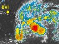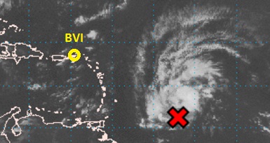
Showers and thunderstorms associated with a broad area of low pressure located about 600 miles east-southeast of the Windward Islands, continue to show signs of organization and a tropical cyclone could be forming. If this trend continues, then a tropical depression or a tropical storm would likely form later today while the system moves west-northwestwards to westwards at about 20mph. as a result, watches and warnings could be required at any time.
Regardless of development, heavy rains and strong gusty winds possibly to tropical storm force are expected to spread mainly over the Windward Islands and portions of the southern Lesser Antilles beginning tonight and continuing into Wednesday. An air force reserve reconnaissance aircraft is scheduled to investigate the disturbance this afternoon.
Whereas this disturbance has a greater chance of affecting the Windward Islands, residents of the BVI & Leeward Islands should closely monitor the progress of this system
Weather Forecast for the BVI September 27th 2016
Today: Partly cloudy to cloudy with a chance of brief morning showers
Tonight: Partly cloudy with a slight chance of a brief shower
Winds: East to east-southeast at 8-16kts [15-30km/h] today becoming East-northeasterly by tonight and increasing slightly by tomorrow.
Seas: Moderate: heights 1.5-1.8m or 5-6ft; A small craft caution remains in effect for marginally safe seas.
Atmospheric Pressure: Below normal
Sunset today: 6:10 pm.
Sunrise tomorrow: 6:08 am.
Please visit our website at www.bviddm.com and subscribe for updates or join us on Facebook at www.facebook.com/bvi.ddm/