SUMMARY OF WATCHES AND WARNINGS IN EFFECT:
A Hurricane Watch is in effect for Puerto Rico, Dominican Republic from Isla Saona to Samana
A Tropical Storm Warning is in effect for Puerto Rico, Vieques, Culebra, U.S. Virgin Islands, Dominican Republic from Isla Saona to Samana
A Tropical Storm Watch is in effect for Dominican Republic from Isla Saona to Punta Palenque, Dominican Republic from Samana to Puerto Plata
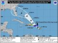
27th August 2019 – At 5 PM, data from the Guadeloupe radar indicate that the center of Tropical Storm Dorian was located near latitude 15.3 North, longitude 62.5 West. Dorian is moving toward the west-northwest near 13 mph and this motion is expected to continue through tonight, followed by a turn toward the northwest on Wednesday. On the forecast track, the center of Dorian will move across the northeastern Caribbean Sea tonight, pass over or near western and central Puerto Rico on Wednesday, and move near or just east of eastern Hispaniola Wednesday night. On Thursday night and Friday, the center of Dorian is forecast to move near or to the east of the Turks and Caicos and the southeastern Bahamas.
Maximum sustained winds remain near 50 mph with higher gusts. Slow strengthening is forecast during the next 24 hours, and Dorian is forecast to be near hurricane strength when it approaches Puerto Rico on Wednesday. Some weakening is expected after Dorian moves across the higher terrain of Puerto Rico Wednesday night. Dorian is expected to gradually re-strengthen on Thursday and Friday while passing near or to the east of the Turks and Caicos and southeastern Bahamas.
Tropical storm-force winds extend outward up to 45 miles from the centre.
The estimated minimum central pressure is 1005 mb.
Impact on the British Virgin Islands
- British Virgin Islands could begin experiencing wind gusts as early as Tuesday evening.
- Rain bands and squall like conditions from Dorian is expected.
- Rainfall estimates in the range of 1–3 inches with isolated amounts of 4 inches are possible in some areas.
What to do
Keep monitoring the system as it progresses further eastward for any change in its path and intensity.
Review your family plans and check for items you may need, check your homes, shutters, drainage paths or specific areas. This will avoid trying to do and remember preparation activities at last minute.
Persons can also download the Alert app in the Apple App store or Google Play store to receive updates of any hazards affecting the Territory.
You can also visit the DDM’s webpage at www.bviddm.com and subscribe for updates or like us on Facebook at www.facebook.com/bvi.ddm.
Disclaimer: The Department of Disaster Management (DDM) is not an official Meteorological Office. The Information disseminated by the Department is gathered from a number of professional sources used or contracted by the DDM to provide such information. This information is to be used as a guide by anyone who has interest in local weather conditions. By no means can the DDM or the BVI Government be held accountable by anyone who uses this information appropriately for legal evidence or in justification of any decision which may result in the loss of finances, property or life.