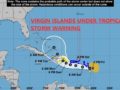
At 11am, Tropical Storm Fiona is approximately 425 miles ESE from Road Town; The Virgin Islands is still under a Tropical Storm Watch. A Tropical Storm Watch means that tropical storm conditions are possible within the watch area, generally within 48 hours. Persons are asked to make sure your preparedness plans are in place and stay tuned to DDM social media pages and local radio stations for updates.
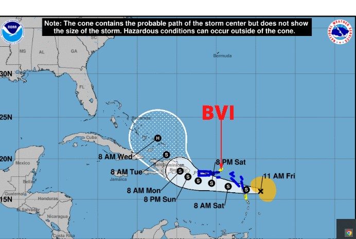
At 1100 AM AST (1500 UTC), the center of Tropical Storm Fiona was located near latitude 16.0 North, longitude 59.4 West. Fiona is moving toward the west near 14 mph (22 km/h). A westward motion with a decrease in forward speed is expected through early Sunday, followed by a turn toward the west-northwest and northwest Sunday and Sunday night. On the forecast track, the center of Fiona is expected to move across the Leeward Islands tonight, near or just south of the Virgin Islands and Puerto Rico Saturday into Sunday, and approach the southern coast of the Dominican Republic Sunday night and early Monday.
Data from Air Force Reserve and NOAA Hurricane Hunter aircraft indicate that maximum sustained winds are near 50 mph (85 km/h) with higher gusts. Gradual strengthening is forecast during the next few days.
Tropical-storm-force winds extend outward up to 140 miles (220 km)from the center.
The estimated minimum central pressure is 1005 mb (29.68 inches).
HAZARDS AFFECTING LAND
WIND: Tropical storm conditions are expected across portions of the Leeward Islands within the warning area beginning this afternoon and will spread westward to the U.S. Virgin Islands on Saturday and across Puerto Rico late Saturday and Saturday night. Tropical storm conditions are possible on Dominica this evening or tonight and across the British Virgin Islands on Saturday.
RAINFALL: Fiona is forecast to produce the following rainfall totals: British and U.S. Virgin Islands: 4 to 6 inches These rains may produce flash and urban flooding, along with mudslides in areas of higher terrain, particularly southern and eastern Puerto Rico and the eastern Dominican Republic.
STORM SURGE: Localized coastal flooding will be possible along the coasts of the U.S. Virgin Islands and Puerto Rico in areas of onshore winds Saturday into Sunday.
SURF: Swells generated by Fiona are affecting the Leeward and northern Windward Islands, and are expected to spread westward to the Virgin Islands and Puerto Rico today. Swells will then reach the northern coast of Hispaniola, the Turks and Caicos Islands, and the southeastern Bahamas over the weekend. These conditions could cause life-threatening surf and rip current conditions. Please consult products from your local weather office.
Forecaster Berg
𝗖𝗼𝗻𝘁𝗶𝗻𝘂𝗲 𝘁𝗼 𝗰𝗵𝗲𝗰𝗸 𝘁𝗵𝗲 𝗗𝗗𝗠 𝗮𝗽𝗽 , 𝗙𝗮𝗰𝗲𝗯𝗼𝗼𝗸, 𝗜𝗻𝘀𝘁𝗮𝗴𝗿𝗮𝗺, 𝗧𝘄𝗶𝘁𝘁𝗲𝗿 𝗽𝗮𝗴𝗲𝘀 𝗮𝗻𝗱 𝗼𝘂𝗿 𝘄𝗲𝗯𝘀𝗶𝘁𝗲 𝘄𝘄𝘄.𝗯𝘃𝗶𝗱𝗱𝗺.𝗰𝗼𝗺/ 𝗱𝗮𝗶𝗹𝘆 𝗳𝗼𝗿 𝘂𝗽𝗱𝗮𝘁𝗲𝘀.
𝘿𝙞𝙨𝙘𝙡𝙖𝙞𝙢𝙚𝙧: 𝙏𝙝𝙚 𝘿𝙚𝙥𝙖𝙧𝙩𝙢𝙚𝙣𝙩 𝙤𝙛 𝘿𝙞𝙨𝙖𝙨𝙩𝙚𝙧 𝙈𝙖𝙣𝙖𝙜𝙚𝙢𝙚𝙣𝙩 (𝘿𝘿𝙈) 𝙞𝙨 𝙣𝙤𝙩 𝙖𝙣 𝙤𝙛𝙛𝙞𝙘𝙞𝙖𝙡 𝙈𝙚𝙩𝙚𝙤𝙧𝙤𝙡𝙤𝙜𝙞𝙘𝙖𝙡 𝙊𝙛𝙛𝙞𝙘𝙚. 𝙏𝙝𝙚 𝙄𝙣𝙛𝙤𝙧𝙢𝙖𝙩𝙞𝙤𝙣 𝙙𝙞𝙨𝙨𝙚𝙢𝙞𝙣𝙖𝙩𝙚𝙙 𝙗𝙮 𝙩𝙝𝙚 𝘿𝙚𝙥𝙖𝙧𝙩𝙢𝙚𝙣𝙩 𝙞𝙨 𝙜𝙖𝙩𝙝𝙚𝙧𝙚𝙙 𝙛𝙧𝙤𝙢 𝙖 𝙣𝙪𝙢𝙗𝙚𝙧 𝙤𝙛 𝙥𝙧𝙤𝙛𝙚𝙨𝙨𝙞𝙤𝙣𝙖𝙡 𝙨𝙤𝙪𝙧𝙘𝙚𝙨 𝙪𝙨𝙚𝙙 𝙤𝙧 𝙘𝙤𝙣𝙩𝙧𝙖𝙘𝙩𝙚𝙙 𝙗𝙮 𝙩𝙝𝙚 𝘿𝘿𝙈 𝙩𝙤 𝙞𝙢𝙥𝙧𝙤𝙫𝙞𝙙𝙚 𝙨𝙪𝙘𝙝 𝙞𝙣𝙛𝙤𝙧𝙢𝙖𝙩𝙞𝙤𝙣. 𝙏𝙝𝙞𝙨 𝙞𝙣𝙛𝙤𝙧𝙢𝙖𝙩𝙞𝙤𝙣 𝙞𝙨 𝙩𝙤 𝙗𝙚 𝙪𝙨𝙚𝙙 𝙖𝙨 𝙖 𝙜𝙪𝙞𝙙𝙚 𝙗𝙮 𝙖𝙣𝙮𝙤𝙣𝙚 𝙬𝙝𝙤 𝙝𝙖𝙨 𝙞𝙣𝙩𝙚𝙧𝙚𝙨𝙩 𝙞𝙣 𝙡𝙤𝙘𝙖𝙡 𝙬𝙚𝙖𝙩𝙝𝙚𝙧 𝙘𝙤𝙣𝙙𝙞𝙩𝙞𝙤𝙣𝙨. 𝘽𝙮 𝙣𝙤 𝙢𝙚𝙖𝙣𝙨 𝙘𝙖𝙣 𝘿𝘿𝙈 𝙤𝙧 𝙩𝙝𝙚 𝘽𝙑𝙄 𝙂𝙤𝙫𝙚𝙧𝙣𝙢𝙚𝙣𝙩 𝙗𝙚 𝙝𝙚𝙡𝙙 𝙖𝙘𝙘𝙤𝙪𝙣𝙩𝙖𝙗𝙡𝙚 𝙗𝙮 𝙖𝙣𝙮𝙤𝙣𝙚 𝙬𝙝𝙤 𝙪𝙨𝙚𝙨 𝙩𝙝𝙞𝙨 𝙞𝙣𝙛𝙤𝙧𝙢𝙖𝙩𝙞𝙤𝙣 𝙖𝙥𝙥𝙧𝙤𝙥𝙧𝙞𝙖𝙩𝙚𝙡𝙮 𝙛𝙤𝙧 𝙡𝙚𝙜𝙖𝙡 𝙚𝙫𝙞𝙙𝙚𝙣𝙘𝙚 𝙤𝙧 𝙞𝙣 𝙟𝙪𝙨𝙩𝙞𝙛𝙞𝙘𝙖𝙩𝙞𝙤𝙣 𝙤𝙛 𝙖𝙣𝙮 𝙙𝙚𝙘𝙞𝙨𝙞𝙤𝙣 𝙬𝙝𝙞𝙘𝙝 𝙢𝙖𝙮 𝙧𝙚𝙨𝙪𝙡𝙩 𝙞𝙣 𝙩𝙝𝙚 𝙡𝙤𝙨𝙨 𝙤𝙛 𝙛𝙞𝙣𝙖𝙣𝙘𝙚𝙨, 𝙥𝙧𝙤𝙥𝙚𝙧𝙩𝙮 𝙤𝙧 𝙡𝙞𝙛𝙚.