…FIONA FORECAST TO BECOME A HURRICANE LATER TODAY…
SUMMARY OF 500 AM AST…0900 UTC…INFORMATION
LOCATION…17.1N 65.8W
ABOUT 120 MI…193 KM SSW OF ROAD TOWN
MAXIMUM SUSTAINED WINDS…60 MPH…95 KM/H
PRESENT MOVEMENT…WNW OR 285 DEGREES AT 9 MPH…15 KM/H
MINIMUM CENTRAL PRESSURE…1002 MB…29.59 INCHES
BASED ON THE LATEST FORECAST TRACK INFORMATION, TROPICAL STORM FIONA IS NOW PASSING SOUTH-SOUTHWEST OF THE BRITISH VIRGIN ISLANDS AT A DISTANCE OF ABOUT 120 MILES FROM ROAD TOWN. THE BRITISH VIRGIN ISLANDS MAY EXPERIENCE TROPICAL STORM FORCE WINDS THROUGHOUT TODAY SUNDAY.
MORE SPECIFIC IMPACTS INCLUDE:
WINDS: 30 TO 40 MPH SUSTAINED WINDS WITH POSSIBLE HIGHER GUSTS TO 55 MPH ARE LIKELY. THESE WINDY CONDITIONS COULD PRODUCE FLYING DEBRIS FROM SMALL OBJECTS AND DAMAGE TO WEAK INFRASTRUCTURE.
RAINFALL: RAINFALL ACCUMULATIONS OF 1 TO 4 INCHES ARE POSSIBLE OVER THE NEXT 24 HOURS. THIS COULD PRODUCE FLASH FLOODING IN LOW LYING AND FLOOD PRONE AREAS AS WELL AS MUDSLIDES.
SEAS: ALONG WITH STORM SURGE, SEAS COULD REACH UP TO 15 FEET WHICH COULD PRODUCE BATTERING WAVES AND RIP CURRENTS. AS A RESULT, MARINERS AND BEACH-GOERS SHOULD STAY IN PORT AND AVOID BEACHES.
RESIDENTS IN THE BRITISH VIRGIN ISLANDS SHOULD CONTINUE TO CLOSELY MONITOR THE PROGRESS OF FIONA
SUMMARY OF WATCHES AND WARNINGS IN EFFECT:
A Tropical Storm Warning is in still in effect for the British Virgin Islands.
A Tropical Storm Warning means that tropical storm conditions are expected somewhere within the warning area within 36 hours.
𝗗𝗜𝗦𝗖𝗨𝗦𝗦𝗜𝗢𝗡 𝗔𝗡𝗗 𝗢𝗨𝗧𝗟𝗢𝗢𝗞
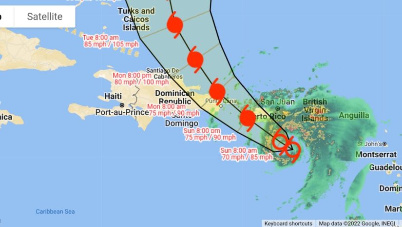
At 500 AM AST (0900 UTC), the center of Tropical Storm Fiona was located near latitude 17.1 North, longitude 65.8 West which is about 120 miles south of Road Town. Fiona is moving toward the west-northwest near 8 mph (13 km/h).
A northwestward motion is expected to begin later today and continue through Monday, followed by a turn toward the north-northwest on Tuesday.
On the forecast track, the center of Fiona will approach Puerto Rico this morning, and move near or over Puerto Rico this afternoon or evening. Fiona will then move near the northern coast of the Dominican Republic tonight and Monday, and near or to the east of the Turks and Caicos Islands on Tuesday.
Fiona has continued to show signs of better organization in Doppler radar data from San Juan this morning, and earlier data from an Air Force Hurricane Hunter aircraft indicate that the storm has indeed strengthened.
The aircraft reported peak flight-level (700 mb) winds of 57 kt, along with several instances of SFMR winds greater than 50 kt and a peak of 57 kt in the northeastern quadrant of the storm.
Also, a center dropsonde indicated that the minimum pressure had fallen a few millibars to 994 mb. Based on these data, the initial intensity is raised to 55 kt for this advisory.
Tropical-storm-force winds extend outward up to 140 miles (220 km) from the center.
A weather station at Teagues Bay, St. Croix recently reported a wind gust of 59 mph (94 km/h). A wind gust of 55 mph (89 km/h) was recently reported at Henry E. Rohlsen Airport on St. Croix.
The estimated minimum central pressure based on earlier aircraft data is 994 mb (29.36 inches).
WIND: Hurricane conditions are expected on Puerto Rico today, and are expected in portions of the eastern Dominican Republic tonight and Monday. Hurricane conditions are possible in the U.S. Virgin Islands this morning.
Hurricane conditions are possible within the hurricane watch area in the Dominican Republic tonight and Monday. Tropical storm conditions are occurring in the U.S. and British Virgin Islands and are spreading westward across Puerto Rico.
These conditions are expected to reach portions of the Dominican Republic later today. Tropical storm conditions are possible across the watch area in the Dominican Republic tonight, and in the Turks and Caicos Islands and southeastern Bahamas by early Tuesday.