National Hurricane Centre Forecaster Brown 8pm update.
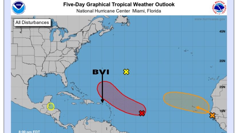
1. A broad area of low pressure located about 875 miles east of the Lesser Antilles is producing a large area of disorganized cloudiness and thunderstorms. Although environmental conditions are only marginally conducive, some gradual development of this system is expected over the next several days and a tropical depression is likely to form later this week. The disturbance is forecast to move slowly toward the west and then west-northwest at 5 to 10 mph, toward the adjacent waters of the northern Leeward Islands.
2. Shower activity associated with a small low pressure system located about 600 miles east of Bermuda remains limited. Strong upper-level winds and dry air are expected to prevent development while the system drifts south-southwestward over the next day or so. The system is likely to dissipate later this week.
3. A tropical wave accompanied by a broad area of low pressure is located near the west coast of Africa. This system is forecast to move offshore tonight, and some gradual development is possible over the next few days while it moves generally westward to west-northwestward. The system could become a short-lived tropical depression over the far eastern Atlantic waters during the next few days. By late this week, the disturbance is forecast to move over cooler waters and further development is not likely after that time. Regardless of development, the system could bring locally heavy rainfall to portions of the Cabo Verde Islands by Wednesday.
4. A trough of low pressure could develop over the northwestern Caribbean Sea later this week. The system however, is likely to move inland over Central America or the southern portion of the Yucatan Peninsula before significant development can occur.
𝗔𝘁 𝘁𝗵𝗶𝘀 𝘁𝗶𝗺𝗲 𝘁𝗵𝗲𝗿𝗲 𝗮𝗿𝗲 𝗻𝗼 𝘄𝗮𝘁𝗰𝗵𝗲𝘀 𝗼𝗿 𝘄𝗮𝗿𝗻𝗶𝗻𝗴𝘀 𝗳𝗼𝗿 𝘁𝗵𝗲 𝗩𝗶𝗿𝗴𝗶𝗻 𝗜𝘀𝗹𝗮𝗻𝗱𝘀. 𝗣𝗲𝗿𝘀𝗼𝗻𝘀 𝗺𝘂𝘀𝘁 𝗰𝗼𝗻𝘁𝗶𝗻𝘂𝗲 𝘁𝗼 𝗺𝗼𝗻𝗶𝘁𝗼𝗿 𝘁𝗵𝗲 𝗔𝘁𝗹𝗮𝗻𝘁𝗶𝗰 𝗶𝗻 𝗰𝗮𝘀𝗲 𝗼𝗳 𝗮𝗻𝘆 𝗰𝗵𝗮𝗻𝗴𝗲 𝘄𝗶𝘁𝗵 𝘁𝗵is 𝘀𝘆𝘀𝘁𝗲𝗺.
𝗖𝗼𝗻𝘁𝗶𝗻𝘂𝗲 𝘁𝗼 𝗰𝗵𝗲𝗰𝗸 𝘁𝗵𝗲 𝗗𝗗𝗠 𝗮𝗽𝗽 , 𝗙𝗮𝗰𝗲𝗯𝗼𝗼𝗸, 𝗜𝗻𝘀𝘁𝗮𝗴𝗿𝗮𝗺, 𝗧𝘄𝗶𝘁𝘁𝗲𝗿 𝗽𝗮𝗴𝗲𝘀 𝗮𝗻𝗱 𝗼𝘂𝗿 𝘄𝗲𝗯𝘀𝗶𝘁𝗲 𝘄𝘄𝘄.𝗯𝘃𝗶𝗱𝗱𝗺.𝗰𝗼𝗺/ 𝗱𝗮𝗶𝗹𝘆 𝗳𝗼𝗿 𝘂𝗽𝗱𝗮𝘁𝗲𝘀.
𝘿𝙞𝙨𝙘𝙡𝙖𝙞𝙢𝙚𝙧: 𝙏𝙝𝙚 𝘿𝙚𝙥𝙖𝙧𝙩𝙢𝙚𝙣𝙩 𝙤𝙛 𝘿𝙞𝙨𝙖𝙨𝙩𝙚𝙧 𝙈𝙖𝙣𝙖𝙜𝙚𝙢𝙚𝙣𝙩 (𝘿𝘿𝙈) 𝙞𝙨 𝙣𝙤𝙩 𝙖𝙣 𝙤𝙛𝙛𝙞𝙘𝙞𝙖𝙡 𝙈𝙚𝙩𝙚𝙤𝙧𝙤𝙡𝙤𝙜𝙞𝙘𝙖𝙡 𝙊𝙛𝙛𝙞𝙘𝙚. 𝙏𝙝𝙚 𝙄𝙣𝙛𝙤𝙧𝙢𝙖𝙩𝙞𝙤𝙣 𝙙𝙞𝙨𝙨𝙚𝙢𝙞𝙣𝙖𝙩𝙚𝙙 𝙗𝙮 𝙩𝙝𝙚 𝘿𝙚𝙥𝙖𝙧𝙩𝙢𝙚𝙣𝙩 𝙞𝙨 𝙜𝙖𝙩𝙝𝙚𝙧𝙚𝙙 𝙛𝙧𝙤𝙢 𝙖 𝙣𝙪𝙢𝙗𝙚𝙧 𝙤𝙛 𝙥𝙧𝙤𝙛𝙚𝙨𝙨𝙞𝙤𝙣𝙖𝙡 𝙨𝙤𝙪𝙧𝙘𝙚𝙨 𝙪𝙨𝙚𝙙 𝙤𝙧 𝙘𝙤𝙣𝙩𝙧𝙖𝙘𝙩𝙚𝙙 𝙗𝙮 𝙩𝙝𝙚 𝘿𝘿𝙈 𝙩𝙤 𝙞𝙢𝙥𝙧𝙤𝙫𝙞𝙙𝙚 𝙨𝙪𝙘𝙝 𝙞𝙣𝙛𝙤𝙧𝙢𝙖𝙩𝙞𝙤𝙣. 𝙏𝙝𝙞𝙨 𝙞𝙣𝙛𝙤𝙧𝙢𝙖𝙩𝙞𝙤𝙣 𝙞𝙨 𝙩𝙤 𝙗𝙚 𝙪𝙨𝙚𝙙 𝙖𝙨 𝙖 𝙜𝙪𝙞𝙙𝙚 𝙗𝙮 𝙖𝙣𝙮𝙤𝙣𝙚 𝙬𝙝𝙤 𝙝𝙖𝙨 𝙞𝙣𝙩𝙚𝙧𝙚𝙨𝙩 𝙞𝙣 𝙡𝙤𝙘𝙖𝙡 𝙬𝙚𝙖𝙩𝙝𝙚𝙧 𝙘𝙤𝙣𝙙𝙞𝙩𝙞𝙤𝙣𝙨. 𝘽𝙮 𝙣𝙤 𝙢𝙚𝙖𝙣𝙨 𝙘𝙖𝙣 𝘿𝘿𝙈 𝙤𝙧 𝙩𝙝𝙚 𝘽𝙑𝙄 𝙂𝙤𝙫𝙚𝙧𝙣𝙢𝙚𝙣𝙩 𝙗𝙚 𝙝𝙚𝙡𝙙 𝙖𝙘𝙘𝙤𝙪𝙣𝙩𝙖𝙗𝙡𝙚 𝙗𝙮 𝙖𝙣𝙮𝙤𝙣𝙚 𝙬𝙝𝙤 𝙪𝙨𝙚𝙨 𝙩𝙝𝙞𝙨 𝙞𝙣𝙛𝙤𝙧𝙢𝙖𝙩𝙞𝙤𝙣 𝙖𝙥𝙥𝙧𝙤𝙥𝙧𝙞𝙖𝙩𝙚𝙡𝙮 𝙛𝙤𝙧 𝙡𝙚𝙜𝙖𝙡 𝙚𝙫𝙞𝙙𝙚𝙣𝙘𝙚 𝙤𝙧 𝙞𝙣 𝙟𝙪𝙨𝙩𝙞𝙛𝙞𝙘𝙖𝙩𝙞𝙤𝙣 𝙤𝙛 𝙖𝙣𝙮 𝙙𝙚𝙘𝙞𝙨𝙞𝙤𝙣 𝙬𝙝𝙞𝙘𝙝 𝙢𝙖𝙮 𝙧𝙚𝙨𝙪𝙡𝙩 𝙞𝙣 𝙩𝙝𝙚 𝙡𝙤𝙨𝙨 𝙤𝙛 𝙛𝙞𝙣𝙖𝙣𝙘𝙚𝙨, 𝙥𝙧𝙤𝙥𝙚𝙧𝙩𝙮 𝙤𝙧 𝙡𝙞𝙛𝙚.


