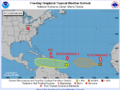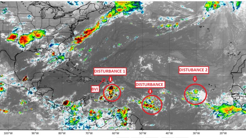
30th August 2020 – Disturbance 1 is a well-defined tropical wave located along 62W, or over the Lesser Antilles and eastern Caribbean. It is moving to the west near 20 mph. This tropical wave will move across the eastern Caribbean today and may create unsettling weather conditions for the British Virgin Islands later tonight. Thunderstorms have increased significantly with the disturbance. However, the thunderstorms are not well organized. The disturbance may develop later this coming week as it moves into the western Caribbean and approaches Central America. It is becoming likely this disturbance will remain south of the Bay of Campeche and Gulf of Mexico late this upcoming week. There is a 40 percent chance of development over the next seven days.
A disturbance has been identified over the central Atlantic over 1000 miles to the west of the Leeward Islands along 44W however it is not visible on the forecast map of the National Hurricane Centre (NHC) at this point. It is moving to the west-northwest at 15 mph. There is a good low level rotation with the disturbance. However, thunderstorms are very limited at this time. The disturbance will likely reach the northeastern Caribbean by Tuesday bringing unsettling weather to the British Virgin Islands during that period and could move over or just north of the Greater Antilles and over the southern Bahamas Wednesday and Thursday. Some of our model guidance indicates that this Disturbance 38 will be the one that reaches the southern Gulf of Mexico by Friday or Saturday. However, most models indicate that it may be a weak tropical system. There is a 30 percent chance of development over the next seven days.
Disturbance 2 is located to the southwest of the Cabo Verde Islands near 13N, 29W. The disturbance is moving to the west-northwest at 7 mph and will likely be slow to move over the eastern Atlantic over the next few days. It is forecast to move to the west-northwest across the Atlantic later this week. The disturbance may develop into a tropical depression or tropical storm over the eastern and central Atlantic for the latter half of this week. It may pass to the northeast of the northern Leeward Islands next weekend or early the following week. There is a 40 percent chance of tropical development over the next seven days.
Residents should continue to monitor the activity in the Atlantic and have plans prepared if needed.
Persons at home and abroad are encouraged to download the DDM’s Alert app in the Apple App store or Google Play store to receive updates of any hazards affecting the Territory.
You can also visit the DDM’s webpage at www.bviddm.com and subscribe for updates or like us on Facebook at www.facebook.com/bvi.ddm.
Disclaimer: The Department of Disaster Management (DDM) is not an official Meteorological Office. The Information disseminated by the Department is gathered from a number of professional sources used or contracted by the DDM to provide such information. This information is to be used as a guide by anyone who has interest in local weather conditions. By no means can the DDM or the BVI Government be held accountable by anyone who uses this information appropriately for legal evidence or in justification of any decision which may result in the loss of finances, property or life.