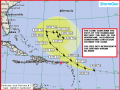
HURRICANE JOSE A CATEGORY 3 HURRICANE…WATCHES ISSUED FOR SOME LEEWARD ISLANDS
Jose continues to strengthen this evening with current maximum sustained winds estimated to be near 125 mph. However, there is no hurricane reconnaissance aircraft data from this system yet to confirm the winds. Forecasters are projecting the system to reach a peak intensity of 140 mph within the next 12 to 24 hours. At this time, forecasters do not think the system will become a category 5 hurricane like Irma.
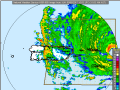
The Antigua and Barbuda Meteorological Services has issued a Hurricane Watch for Antigua & Barbuda and Tropical Storm Watch for Anguilla, Montserrat, St. Kitts and Nevis, Saba and St. Eustatius. Persons in the remaining Leeward Islands should pay close attention to the progress of Hurricane Jose as more watches may be issued within the next day.
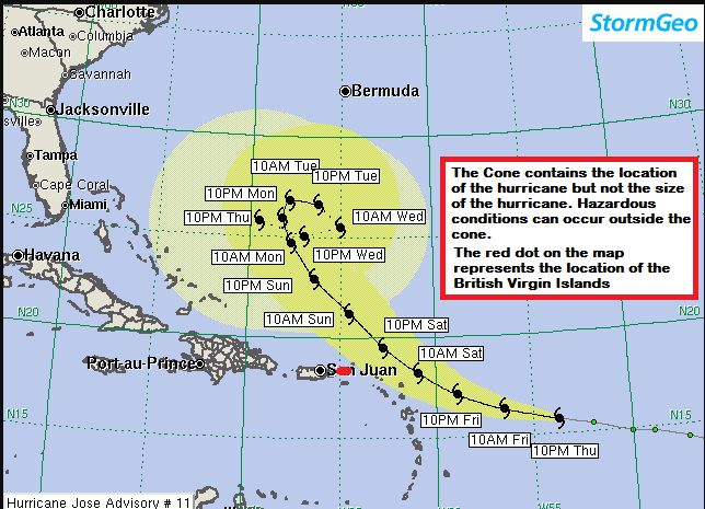
Jose will make its closest approach to the Leeward Islands on Saturday and is forecast to be a 125 mph to 130 mph hurricane at that time. Jose is a smaller and more compact storm compared to Irma. Therefore, the destructive winds will likely be limited to very near the center.
Squalls could impact the Leeward Islands on Saturday into Sunday morning. Sustained winds of 50 mph to 65 mph are possible for the northernmost Leeward Islands on Saturday into early Sunday morning while Jose makes its closest approach.
Forecasters’ current track has the center tracking about 80 miles north of the Leeward Islands. This would be close enough to produce periods of moderate to heavy rain and tropical storm force winds over the Leeward Islands. Some of model guidance suggests that the squalls and strong winds will not extend as far south as the current forecast. However, considering the damage already inflicted by Irma, it will not take very high winds to cause additional damage to structures already hit hard by Irma.
Please continue to monitor local media stations, DDM’s website (bviddm.com) and Facebook at BVIDDM for regular updates.
Disclaimer: The Department of Disaster Management (DDM) is not an official Meteorological Office. The Information disseminated by the Department is gathered from a number of professional sources used or contracted by the DDM to provide such information. This information is to be used as a guide by anyone who has interest in local weather conditions. By no means can the DDM or the BVI Government be held accountable by anyone who uses this information appropriately for legal evidence or in justification of any decision which may result in the loss of finances, property or life.