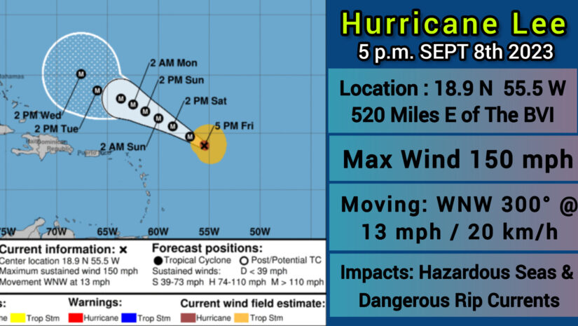
CORE OF POWERFUL HURRICANE LEE EXPECTED TO PASS WELL NORTH OF THE NORTHERN LEEWARD ISLANDS THIS WEEKEND…
DISCUSSION AND OUTLOOK
———————-
At 500 PM AST (2100 UTC
Hurricane Lee is expected to keep the same motion and is
expected to continue through early next week with a significant
decrease in forward speed. On the forecast track, Lee is expected
to pass well to the north of the northern Leeward Islands, the
Virgin Islands, and Puerto Rico over the weekend and into early
next week.
Maximum sustained winds are near 150 mph (240 km/h) with higher
gusts. Lee is a category 4 hurricane on the Saffir-Simpson
Hurricane Wind Scale. Some fluctuations in intensity are likely
over the next few days, however Lee is expected to remain a
powerful major hurricane through early next week.
Hurricane-force winds extend outward up to 35 miles (55 km) from the center and tropical-storm-force winds extend outward up to 150 miles
(240 km).
The estimated minimum central pressure is 942 mb (27.82 inches).
HAZARDS AFFECTING LAND
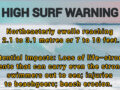
SURF: Swells generated by Lee are affecting portions of the
Lesser Antilles, and will reach the British and U.S. Virgin Islands, Puerto Rico, Hispaniola, the Turks and Caicos Islands, the
Bahamas, and Bermuda this weekend.
These swells are likely to cause life-threatening surf and rip current conditions. Dangerous surf andrip currents are expected to begin along most of the U.S. East Coast beginning Sunday and Monday. Please consult products from your
local weather office.
𝗖𝗼𝗻𝘁𝗶𝗻𝘂𝗲 𝘁𝗼 𝗰𝗵𝗲𝗰𝗸 𝘁𝗵𝗲 𝗗𝗗𝗠 𝗮𝗽𝗽, 𝗙𝗮𝗰𝗲𝗯𝗼𝗼𝗸, 𝗜𝗻𝘀𝘁𝗮𝗴𝗿𝗮𝗺, 𝗧𝘄𝗶𝘁𝘁𝗲𝗿, 𝗼𝘂𝗿 𝘄𝗲𝗯𝘀𝗶𝘁𝗲 𝘄𝘄𝘄.𝗯𝘃𝗶𝗱𝗱𝗺.𝗰𝗼𝗺 𝗮𝗻𝗱 𝘄𝗲𝗮𝘁𝗵𝗲𝗿 𝘀𝘁𝗲𝗺 𝗮𝘁 𝗵𝘁𝘁𝗽𝘀://𝗯𝘃𝗶.𝘄𝗲𝗮𝘁𝗵𝗲𝗿𝘀𝘁𝗲𝗺.𝗰𝗼𝗺/𝘁𝗼𝗿𝘁𝗼𝗹𝗮 𝗳𝗼𝗿 𝘂𝗽𝗱𝗮𝘁𝗲𝘀.
Disclaimer: The Department of Disaster Management (DDM) is not a Meteorological Office. Information shared by the Department is gathered from a number of professional sources contracted by the Department. This information should be used as a guide for anyone who has an interest in local weather conditions. By no means can DDM or the Government of the Virgin Islands be held accountable by anyone who uses this information appropriately for legal evidence or in justification of any decision which may result in the loss of finances, property or life.