TROPICAL STORM LEE ALERT STATEMENT FROM ANTIGUA AND BARBUDA METEOROLOGICAL SERVICES
TUE SEP 5th 2023
…TROPICAL DEPRESSION THIRTEEN HAS BECOME TROPICAL STORM LEE…
…LEE COULD BRING SOME IMPACTS TO THE AREA…
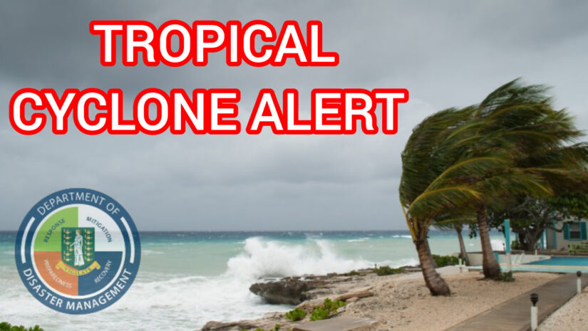
𝗔 𝘁𝗿𝗼𝗽𝗶𝗰𝗮𝗹 𝗰𝘆𝗰𝗹𝗼𝗻𝗲 𝗮𝗹𝗲𝗿𝘁 𝗶𝘀 𝗶𝗻 𝗲𝗳𝗳𝗲𝗰𝘁 𝗳𝗼𝗿 𝗔𝗻𝘁𝗶𝗴𝘂𝗮 𝗮𝗻𝗱 𝗕𝗮𝗿𝗯𝘂𝗱𝗮, 𝘁𝗵𝗲 𝗟𝗲𝗲𝘄𝗮𝗿𝗱 𝗜𝘀𝗹𝗮𝗻𝗱𝘀 𝗮𝗻𝗱 𝘁𝗵𝗲 𝗕𝗿𝗶𝘁𝗶𝘀𝗵 𝗩𝗶𝗿𝗴𝗶𝗻 𝗜𝘀𝗹𝗮𝗻𝗱𝘀. 𝗔 𝘁𝗿𝗼𝗽𝗶𝗰𝗮𝗹 𝗰𝘆𝗰𝗹𝗼𝗻𝗲 𝗮𝗹𝗲𝗿𝘁 𝗺𝗲𝗮𝗻𝘀 𝘁𝗵𝗮𝘁, 𝗶𝗻 𝘁𝗵𝗶𝘀 𝗰𝗮𝘀𝗲, 𝗮 𝘁𝗿𝗼𝗽𝗶𝗰𝗮𝗹 𝗰𝘆𝗰𝗹𝗼𝗻𝗲 𝗶𝘀 𝗶𝗻 𝘁𝗵𝗲 𝗺𝗼𝗻𝗶𝘁𝗼𝗿 𝗮𝗿𝗲𝗮 𝗼𝗳 𝗰𝗼𝗻𝗰𝗲𝗿𝗻 𝘄𝗶𝘁𝗵 𝘁𝗵𝗲 𝗽𝗼𝘁𝗲𝗻𝘁𝗶𝗮𝗹 𝘁𝗼 𝗯𝗲𝗰𝗼𝗺𝗲 𝗮 𝗺𝗮𝗷𝗼𝗿 𝗵𝘂𝗿𝗿𝗶𝗰𝗮𝗻𝗲. 𝗔 𝘁𝗿𝗼𝗽𝗶𝗰𝗮𝗹 𝘀𝘁𝗼𝗿𝗺 𝗼𝗿 𝗵𝘂𝗿𝗿𝗶𝗰𝗮𝗻𝗲 𝘄𝗮𝘁𝗰𝗵 𝘀𝗼𝗺𝗲𝘁𝗶𝗺𝗲 𝘁𝗵𝘂𝗿𝘀𝗱𝗮𝘆 𝗰𝗮𝗻𝗻𝗼𝘁 𝗯𝗲 𝗿𝘂𝗹𝗲𝗱 𝗼𝘂𝘁.
The forecast track of Lee is inherently uncertain due mainly to the notable distance from the Islands. However, a majority of model forecasts continue to indicate that the centre will likely pass a relatively safe distance north of the region. All things considered, in the reasonable worst-case scenario, the system poses an elevated or minor threat to the islands with the potential to cause limited impacts from storm-force winds and high seas, resulting in life-threatening conditions and minor disruptions to daily life.
𝗜𝘁’𝘀 𝗶𝗺𝗽𝗼𝗿𝘁𝗮𝗻𝘁 𝘁𝗼 𝗻𝗼𝘁𝗲 𝘁𝗵𝗮𝘁 𝘁𝗵𝗶𝘀 𝗮𝘀𝘀𝗲𝘀𝘀𝗺𝗲𝗻𝘁 𝗶𝘀 𝘀𝘂𝗯𝗷𝗲𝗰𝘁 𝘁𝗼 𝗰𝗵𝗮𝗻𝗴𝗲 𝗮𝘀 𝘁𝗵𝗲 𝘀𝘆𝘀𝘁𝗲𝗺 𝗺𝗼𝘃𝗲𝘀 𝗰𝗹𝗼𝘀𝗲𝗿 𝘁𝗼 𝘁𝗵𝗲 𝗿𝗲𝗴𝗶𝗼𝗻 𝗮𝗻𝗱 𝗻𝗲𝘄 𝗶𝗻𝗳𝗼𝗿𝗺𝗮𝘁𝗶𝗼𝗻 𝗯𝗲𝗰𝗼𝗺𝗲𝘀 𝗮𝘃𝗮𝗶𝗹𝗮𝗯𝗹𝗲.
To ensure your safety, we strongly recommend having your hurricane disaster plan prepared and ready. additionally, please stay actively vigilant and monitor the progress of this cyclone closely.
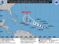
At 5 pm, the centre of Tropical Storm Lee was located near latitude 13.2 North, longitude 41.8 West or about 1353 miles east-southeast of the Leeward Islands or about 1553 miles East-southeast of the British Virgin Islands.
The storm is moving west-northwest near 16 mph and this motion is expected to continue for the next few days with a slight reduction in forward speed.
Maximum sustained winds are near 45 mph with higher gusts.
Lee is forecast to be a hurricane within a couple of days and will likely be a major hurricane by friday.
Tropical-storm-force winds extend outward up to 70 miles from the centre.
On its forecast track, Tropical storm Lee could be near the Islands late F Friday or Saturday , as a major tropical cyclone. it is likely that the Islands will be impacted by hazardous seas.
There is also the possibility of minimal storm-force winds. The specific impacts, if any, remain uncertain given the limited confidence in the eventual path, size and intensity of the system.
Note that there are NO WATCHES OR WARNINGS IN EFFECT AT THIS TIME.
Residents should continue to closely monitor Tropical Storm Lee and ensure that they have their hurricane season plans prepared.
𝗖𝗼𝗻𝘁𝗶𝗻𝘂𝗲 𝘁𝗼 𝗰𝗵𝗲𝗰𝗸 𝘁𝗵𝗲 𝗗𝗗𝗠 𝗮𝗽𝗽, 𝗙𝗮𝗰𝗲𝗯𝗼𝗼𝗸, 𝗜𝗻𝘀𝘁𝗮𝗴𝗿𝗮𝗺, 𝗧𝘄𝗶𝘁𝘁𝗲𝗿 𝗮𝗻𝗱 𝗼𝘂𝗿 𝘄𝗲𝗯𝘀𝗶𝘁𝗲 𝘄𝘄𝘄.𝗯𝘃𝗶𝗱𝗱𝗺.𝗰𝗼𝗺 𝗳𝗼𝗿 𝘂𝗽𝗱𝗮𝘁𝗲𝘀.
Here are the links for our BVIDDM EMERGENCY APP
https://apps.apple.com/ie/app/bviddm-emergency-app/id6449369372
https://play.google.com/store/apps/details?id=com.bviddmapp
Disclaimer: The Department of Disaster Management (DDM) is not a Meteorological Office. Information shared by the Department is gathered from a number of professional sources contracted by the Department. This information should be used as a guide for anyone who has an interest in local weather conditions. By no means can DDM or the Government of the Virgin Islands be held accountable by anyone who uses this information appropriately for legal evidence or in justification of any decision which may result in the loss of finances, property or life.