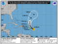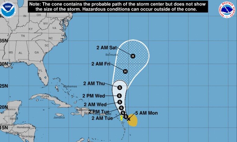
Forecaster Brown of the National Hurricane Centre 5am update At 500 AM AST (0900 UTC), the center of Tropical Storm Philippe was located near latitude 17.1 North, longitude 60.0 West. Philippe is moving toward the northwest near 7 mph (11 km/h), and this motion is expected to continue through early Tuesday. A turn toward the north-northwest is forecast to occur by late Tuesday, followed by a northward motion on Wednesday. On the forecast track, the center of Philippe is expected to pass near or just northeast of the northern Leeward Islands later today and tonight.
Maximum sustained winds are near 50 mph (85 km/h) with higher gusts. Little change in strength is forecast during the next day or so, but Philippe could begin to intensify more significantly around the middle of the week.
Tropical-storm-force winds extend outward up to 175 miles (280 km), primarily east and southeast of the center.
The estimated minimum central pressure is 998 mb (29.47 inches).
LOCATION…17.1N 60.0W
ABOUT 125 MI…200 KM ESE OF BARBUDA
MAXIMUM SUSTAINED WINDS…50 MPH…85 KM/H
PRESENT MOVEMENT…NW OR 315 DEGREES AT 7 MPH…11 KM/H
MINIMUM CENTRAL PRESSURE…998 MB…29.47 INCHES
A Tropical Storm Watch is in effect for…* Antigua, Barbuda Interests elsewhere in the northern Leeward Islands should monitor the progress of this system.