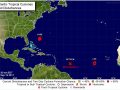
The Department of Disaster Management is monitoring the two tropical systems in the eastern Atlantic that are showings signs for development. Residents are urged to monitor the systems as they have the potential to impact the British Virgin Islands.
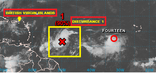
DISTURBANCE 1
Disturbance 1 continues to generate strong showers and thunderstorms. The low-level circulation appears to be becoming better organized, but it is difficult to know if it is already closed. The intensity is analyzed at 35 mph. The disturbance is likely to become a tropical depression later today, and could become a tropical storm tonight or tomorrow. This system is moving quickly to the west-northwest, but it is forecast to slow down as it approaches the Lesser Antilles. Model guidance continues to show that it will be crossing the central Lesser Antilles late Monday or early Tuesday as a moderate tropical storm. The environment is expected to be favorable for further intensification. The disturbance is likely going to become a hurricane in the NE Caribbean Sea. Later, the intensity of the system will depend on how much it interacts with Hispaniola. The American model shows the disturbance going over the island, and weakening much more than indicated while the European model is farther north, and keeps the system stronger. After leaving the Caribbean Sea, it will steadily strengthen possibly affecting the eastern Bahamas, and Turks and Caicos.
Expected Impacts on Land
Leeward Islands: Tropical storm conditions with gusty wind and heavy rain are possible from St. Lucia north to Guadeloupe Island on Monday afternoon through Tuesday morning, resulting in power outages and some flooding. Significant travel delays are possible.
U.S. and British Virgin Islands through Puerto Rico: Tropical storm conditions with strong wind and heavy rain are possible Wednesday through Thursday, resulting in flooding.
TROPICAL DEPRESSION FOURTEEN
Tropical Depression Fourteen remains poorly organized over the far eastern Atlantic. Maximum sustained winds are 35 mph. Movement is to the west-northwest at 10 mph. The tropical depression is expected to become a tropical storm during the weekend as it moves into the central Atlantic. Early next week, wind shear will be increasing over the circulation. This will cause the system to weaken, and possibly become a remnant cyclone by Wednesday. This tropical depression is not a threat to the Caribbean Sea as of this forecast.
Please continue to monitor local media stations, DDM’s website (bviddm.com) and Facebook at BVIDDM for regular updates.
Disclaimer: The Department of Disaster Management (DDM) is not an official Meteorological Office. The Information disseminated by the Department is gathered from a number of professional sources used or contracted by the DDM to provide such information. This information is to be used as a guide by anyone who has interest in local weather conditions. By no means can the DDM or the BVI Government be held accountable by anyone who uses this information appropriately for legal evidence or in justification of any decision which may result in the loss of finances, property or life.