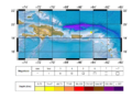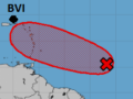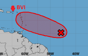
24th August 2019 at 5:00 AM – A tropical disturbance/Invest 99L was located about 850 miles ESE of Barbados. It is moving to the west-northwest near 20 mph. A west-northwest track is expected to bring the system across the Lesser Antilles Tuesday into Wednesday. The system currently has some enhanced rotation and thunderstorm activity associated with it. Conditions are forecast to be at least somewhat favorable for development over the next few days. If development were to occur, forecasters have indicated it appears unlikely at this time that the system would become a hurricane. Instead, forecasters think it could move through the islands of the eastern Caribbean as a tropical storm. The chance of tropical development has increased to 70 percent.
Impact on the British Virgin Islands
Current information has not revealed any impacts for our location at this point in time however, if the system were to continue to develop it could become Tropical Storm Dorian making it the fourth named storm for the 2019 Atlantic Hurricane Season.
What to do
Keep monitoring the system as it progresses further eastward for any change in its path and intensity.
Review your family plans and check for items you may need, check your homes, shutters, drainage paths or specific areas. This is will avoid trying to do and remember certain activities at last minute.
Persons can also download the Alert app in the Apple App store or Google Play store to receive updates of any hazards affecting the Territory.
You can also visit the DDM’s webpage at www.bviddm.com and subscribe for updates or like us on Facebook at www.facebook.com/bvi.ddm.
The DDM will provide a preliminary updates where necessary.
Disclaimer: The Department of Disaster Management (DDM) is not an official Meteorological Office. The Information disseminated by the Department is gathered from a number of professional sources used or contracted by the DDM to provide such information. This information is to be used as a guide by anyone who has interest in local weather conditions. By no means can the DDM or the BVI Government be held accountable by anyone who uses this information appropriately for legal evidence or in justification of any decision which may result in the loss of finances, property or life.
Image credited to the National Hurricane Centre