Hurricane Irma Summary:
Current Location: 18.8 degrees North, 39.1 degrees West
Geographic Reference: Approximately 1760 miles east of the Northern Leeward Islands
Movement: West at 13 mph
Max Winds: 120 mph with higher gusts
Hurricane Force Winds: 25 miles
Current Radius of Tropical Storm-Force Winds: 105 miles
Minimum Central Pressure: 964 Millibars
Key Points
- Irma has regained strength and may develop into a category 4 hurricane by tomorrow.
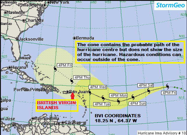
- Irma may pass very close to the northeast Caribbean islands as a major hurricane next Wednesday.
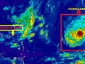
Satellite imagery this afternoon indicates that Irma finished its eyewall replacement cycle a few hours ago and is now strengthening as the new eye shrinks in size. Irma will likely become a Category 4 hurricane tomorrow as it continues tracking generally westward at about 13 mph. Forecasters have made a minor northward track adjustment as Irma passes the Leeward Islands.
The westward turn of Irma has begun. A building mid-level high should cause the hurricane to turn west-southwestward tomorrow and continue through early next week. Thereafter, Irma should reach the southern periphery of the ridge, and begin to move west-northwestward.
Expected Impacts on Land:
Northeast Caribbean Islands: Squalls will reach the area next Tuesday night with possible tropical storm-force or greater winds affecting the area next Wednesday.
The Department of Disaster Management (DDM) is strongly encouraging all persons to use the time now to intensify preparations for any potential impact.
Irma has the potential to cause significant rainfall, strong winds and storm surge across the Territory, if it moves into or near the British Virgin Islands. Residents and businesses in low-lying, coastal and flood prone communities will need to take steps to minimize or prevent flooding, check roofs, clear roof gutters and drains around your property and inspect your cistern outflows. Individuals are encouraged to utilize flood protection items such as flood boards and sand bags to prevent or slow the flow of water into their homes and businesses.
The DDM will continue to monitor this system into the weekend and will provide updates and preparedness information. Please ensure that you are able to access these updates and we urge you to act on the information that is being provided.
Advisories and information can be obtained from local media stations, DDM’s website (bviddm.com) and Facebook at BVIDDM.
Disclaimer: The Department of Disaster Management (DDM) is not an official Meteorological Office. The Information disseminated by the Department is gathered from a number of professional sources used or contracted by the DDM to provide such information. This information is to be used as a guide by anyone who has interest in local weather conditions. By no means can the DDM or the BVI Government be held accountable by anyone who uses this information appropriately for legal evidence or in justification of any decision which may result in the loss of finances, property or life.