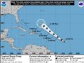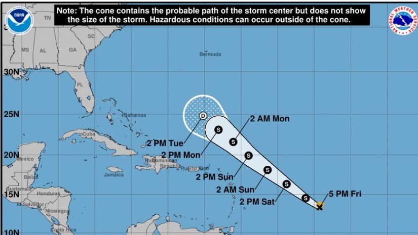
At 500 PM AST (2100 UTC), the center of Tropical Storm Cindy was located near latitude 13.3 North, longitude 49.3 West. About 391 miles south of the Virgin Islands. Cindy is moving toward the west-northwest near 16 mph (26 km/h) and this general motion is expected to continue over the next few days. On the forecast track, the system is expected to remain well east and northeast of the northern Leeward Islands through early next week.
Maximum sustained winds remain near 50 mph (85 km/h) with higher gusts. Some slight strengthening is forecast over the next day or so followed by gradual weakening afterwards.
Tropical-storm-force winds extend outward up to 60 miles (95 km) from the center.
The estimated minimum central pressure is 1003 mb (29.62 inches).
LOCATION…13.3N 49.3W
ABOUT 815 MI…1315 KM E OF THE LESSER ANTILLES
MAXIMUM SUSTAINED WINDS…50 MPH…85 KM/H
PRESENT MOVEMENT…WNW OR 295 DEGREES AT 16 MPH…26 KM/H
MINIMUM CENTRAL PRESSURE…1003 MB…29.62 INCHES
Forecaster Papin
𝗔𝘁 𝘁𝗵𝗶𝘀 𝘁𝗶𝗺𝗲 𝘁𝗵𝗲𝗿𝗲 𝗮𝗿𝗲 𝗻𝗼 𝘄𝗮𝘁𝗰𝗵𝗲𝘀 𝗼𝗿 𝘄𝗮𝗿𝗻𝗶𝗻𝗴𝘀 𝗳𝗼𝗿 𝘁𝗵𝗲 𝗩𝗶𝗿𝗴𝗶𝗻 𝗜𝘀𝗹𝗮𝗻𝗱𝘀. 𝗣𝗲𝗿𝘀𝗼𝗻𝘀 𝗺𝘂𝘀𝘁 𝗰𝗼𝗻𝘁𝗶𝗻𝘂𝗲 𝘁𝗼 𝗺𝗼𝗻𝗶𝘁𝗼𝗿 𝘁𝗵𝗲 𝗔𝘁𝗹𝗮𝗻𝘁𝗶𝗰 𝗶𝗻 𝗰𝗮𝘀𝗲 𝗼𝗳 𝗮𝗻𝘆 𝗰𝗵𝗮𝗻𝗴𝗲 𝘄𝗶𝘁𝗵 𝘁𝗵is 𝘀𝘆𝘀𝘁𝗲𝗺.
𝗖𝗼𝗻𝘁𝗶𝗻𝘂𝗲 𝘁𝗼 𝗰𝗵𝗲𝗰𝗸 𝘁𝗵𝗲 𝗗𝗗𝗠 𝗮𝗽𝗽 , 𝗙𝗮𝗰𝗲𝗯𝗼𝗼𝗸, 𝗜𝗻𝘀𝘁𝗮𝗴𝗿𝗮𝗺, 𝗧𝘄𝗶𝘁𝘁𝗲𝗿 𝗽𝗮𝗴𝗲𝘀 𝗮𝗻𝗱 𝗼𝘂𝗿 𝘄𝗲𝗯𝘀𝗶𝘁𝗲 𝘄𝘄𝘄.𝗯𝘃𝗶𝗱𝗱𝗺.𝗰𝗼𝗺/ 𝗱𝗮𝗶𝗹𝘆 𝗳𝗼𝗿 𝘂𝗽𝗱𝗮𝘁𝗲𝘀
Residents should monitor this system closely and work to complete any seasonal preparations in case this system develops into a threat for the Virgin Islands.
Disclaimer: The Department of Disaster Management (DDM) is not a Meteorological Office. Information shared by the Department is gathered from a number of professional sources contracted by the Department. This information should be used as a guide for anyone who has an interest in local weather conditions. By no means can DDM or the Government of the Virgin Islands be held accountable by anyone who uses this information appropriately for legal evidence or in justification of any decision, which may result in the loss of finances, property or life