close
๐ƒ๐„๐๐‘๐„๐’๐’๐ˆ๐Ž๐ ๐’๐“๐‘๐„๐๐†๐“๐‡๐„๐๐’ ๐ˆ๐๐“๐Ž ๐“๐‘๐Ž๐๐ˆ๐‚๐€๐‹ ๐’๐“๐Ž๐‘๐Œ ๐†๐‘๐€๐‚๐„…

๐ƒ๐„๐๐‘๐„๐’๐’๐ˆ๐Ž๐ ๐’๐“๐‘๐„๐๐†๐“๐‡๐„๐๐’ ๐ˆ๐๐“๐Ž ๐“๐‘๐Ž๐๐ˆ๐‚๐€๐‹ ๐’๐“๐Ž๐‘๐Œ ๐†๐‘๐€๐‚๐„…

August 14, 20211160Views

SUMMARY OF 500 AM AST Sat Aug 14 2021———————————————-

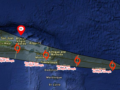
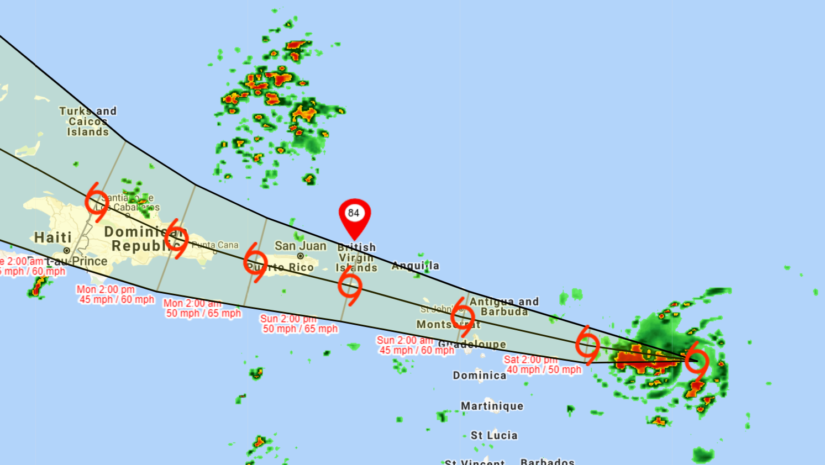
LOCATION…15.8N 55.6WABOUT 420 MI…675 KM E OF THE LEEWARD ISLANDS

ABOUT 524 MILES… 843 ESE OF ROAD TOWN

MAXIMUM SUSTAINED WINDS…40 MPH…65 KM/HPRESENT

MOVEMENT…W OR 280 DEGREES AT 22 MPH…35 KM/HMINIMUM

CENTR…AL PRESSURE…1007 MB…29.74 INCHES

CHANGES WITH THIS ADVISORY:

๐€ ๐“๐ซ๐จ๐ฉ๐ข๐œ๐š๐ฅ ๐’๐ญ๐จ๐ซ๐ฆ ๐–๐š๐ซ๐ง๐ข๐ง๐  ๐ก๐š๐ฌ ๐›๐ž๐ž๐ง ๐ข๐ฌ๐ฌ๐ฎ๐ž๐ ๐Ÿ๐จ๐ซ ๐ญ๐ก๐ž ๐”.๐’. ๐•๐ข๐ซ๐ ๐ข๐ง ๐ˆ๐ฌ๐ฅ๐š๐ง๐๐ฌ๐š๐ง๐ ๐๐ฎ๐ž๐ซ๐ญ๐จ ๐‘๐ข๐œ๐จ, ๐ข๐ง๐œ๐ฅ๐ฎ๐๐ข๐ง๐  ๐•๐ข๐ž๐ช๐ฎ๐ž๐ฌ ๐š๐ง๐ ๐‚๐ฎ๐ฅ๐ž๐›๐ซ๐š. ๐€ ๐“๐ซ๐จ๐ฉ๐ข๐œ๐š๐ฅ ๐’๐ญ๐จ๐ซ๐ฆ ๐–๐š๐ญ๐œ๐ก ๐ซ๐ž๐ฆ๐š๐ข๐ง๐ฌ ๐ข๐ง ๐ž๐Ÿ๐Ÿ๐ž๐œ๐ญ ๐Ÿ๐จ๐ซ…* ๐๐ซ๐ข๐ญ๐ข๐ฌ๐ก ๐•๐ข๐ซ๐ ๐ข๐ง ๐ˆ๐ฌ๐ฅ๐š๐ง๐๐ฌ.

๐“๐ซ๐จ๐ฉ๐ข๐œ๐š๐ฅ ๐ฌ๐ญ๐จ๐ซ๐ฆ ๐œ๐จ๐ง๐๐ข๐ญ๐ข๐จ๐ง๐ฌ ๐š๐ซ๐ž ๐ฉ๐จ๐ฌ๐ฌ๐ข๐›๐ฅ๐ž ๐จ๐ฏ๐ž๐ซ ๐ญ๐ก๐ž ๐๐ซ๐ข๐ญ๐ข๐ฌ๐ก ๐•๐ข๐ซ๐ ๐ข๐ง ๐›๐ž๐ ๐ข๐ง๐ง๐ข๐ง๐  ๐จ๐ง ๐’๐ฎ๐ง๐๐š๐ฒ.

Tropical Storm Warning means that tropical storm conditions areexpected somewhere within the warning area within 36 hours.

A Tropical Storm Watch means that tropical storm conditions arepossible within the watch area, generally within 48 hours.


DISCUSSION AND OUTLOOK———————-

At 500 AM AST (0900 UTC), the center of Tropical Storm Grace was located near latitude 15.8 North, longitude 55.6 West. Grace is moving toward the west near 22 mph (35 km/h). A motion toward the west with a gradual decrease in forward speed is expected during the next few days. On the forecast track, the center of the storm is forecast to move over the Leeward Islands tonight, over the Virgin Islands and Puerto Rico on Sunday, and then over the Dominican Republic on Monday.

Maximum sustained winds are near 40 mph (65 km/h) with higher gusts. Some strengthening is forecast during the next couple of days.ย  Weakening is expected early next week as the system interacts with the Greater Antilles.ย  ย Grace is a small tropical storm. Tropical-storm-force winds extend outward up to 25 miles (35 km) from the center.

The estimated minimum central pressure is 1007 mb (29.74 inches).

๐—–๐—ผ๐—ป๐˜๐—ถ๐—ป๐˜‚๐—ฒ ๐˜๐—ผ ๐—ฐ๐—ต๐—ฒ๐—ฐ๐—ธ ๐˜๐—ต๐—ฒ ๐——๐——๐—  ๐—ฎ๐—ฝ๐—ฝ , ๐—™๐—ฎ๐—ฐ๐—ฒ๐—ฏ๐—ผ๐—ผ๐—ธ, ๐—œ๐—ป๐˜€๐˜๐—ฎ๐—ด๐—ฟ๐—ฎ๐—บ, ๐—ง๐˜„๐—ถ๐˜๐˜๐—ฒ๐—ฟ ๐—ฝ๐—ฎ๐—ด๐—ฒ๐˜€ ๐—ฎ๐—ป๐—ฑ ๐—ผ๐˜‚๐—ฟ ๐˜„๐—ฒ๐—ฏ๐˜€๐—ถ๐˜๐—ฒ ๐˜„๐˜„๐˜„.๐—ฏ๐˜ƒ๐—ถ๐—ฑ๐—ฑ๐—บ.๐—ฐ๐—ผ๐—บ/ ๐—ฑ๐—ฎ๐—ถ๐—น๐˜† ๐—ณ๐—ผ๐—ฟ ๐˜‚๐—ฝ๐—ฑ๐—ฎ๐˜๐—ฒ๐˜€.


๐˜ฟ๐™ž๐™จ๐™˜๐™ก๐™–๐™ž๐™ข๐™š๐™ง: ๐™๐™๐™š ๐˜ฟ๐™š๐™ฅ๐™–๐™ง๐™ฉ๐™ข๐™š๐™ฃ๐™ฉ ๐™ค๐™› ๐˜ฟ๐™ž๐™จ๐™–๐™จ๐™ฉ๐™š๐™ง ๐™ˆ๐™–๐™ฃ๐™–๐™œ๐™š๐™ข๐™š๐™ฃ๐™ฉ (๐˜ฟ๐˜ฟ๐™ˆ) ๐™ž๐™จ ๐™ฃ๐™ค๐™ฉ ๐™–๐™ฃ ๐™ค๐™›๐™›๐™ž๐™˜๐™ž๐™–๐™ก ๐™ˆ๐™š๐™ฉ๐™š๐™ค๐™ง๐™ค๐™ก๐™ค๐™œ๐™ž๐™˜๐™–๐™ก ๐™Š๐™›๐™›๐™ž๐™˜๐™š. ๐™๐™๐™š ๐™„๐™ฃ๐™›๐™ค๐™ง๐™ข๐™–๐™ฉ๐™ž๐™ค๐™ฃ ๐™™๐™ž๐™จ๐™จ๐™š๐™ข๐™ž๐™ฃ๐™–๐™ฉ๐™š๐™™ ๐™—๐™ฎ ๐™ฉ๐™๐™š ๐˜ฟ๐™š๐™ฅ๐™–๐™ง๐™ฉ๐™ข๐™š๐™ฃ๐™ฉ ๐™ž๐™จ ๐™œ๐™–๐™ฉ๐™๐™š๐™ง๐™š๐™™ ๐™›๐™ง๐™ค๐™ข ๐™– ๐™ฃ๐™ช๐™ข๐™—๐™š๐™ง ๐™ค๐™› ๐™ฅ๐™ง๐™ค๐™›๐™š๐™จ๐™จ๐™ž๐™ค๐™ฃ๐™–๐™ก ๐™จ๐™ค๐™ช๐™ง๐™˜๐™š๐™จ ๐™ช๐™จ๐™š๐™™ ๐™ค๐™ง ๐™˜๐™ค๐™ฃ๐™ฉ๐™ง๐™–๐™˜๐™ฉ๐™š๐™™ ๐™—๐™ฎ ๐™ฉ๐™๐™š ๐˜ฟ๐˜ฟ๐™ˆ ๐™ฉ๐™ค ๐™ž๐™ข๐™ฅ๐™ง๐™ค๐™ซ๐™ž๐™™๐™š ๐™จ๐™ช๐™˜๐™ ๐™ž๐™ฃ๐™›๐™ค๐™ง๐™ข๐™–๐™ฉ๐™ž๐™ค๐™ฃ. ๐™๐™๐™ž๐™จ ๐™ž๐™ฃ๐™›๐™ค๐™ง๐™ข๐™–๐™ฉ๐™ž๐™ค๐™ฃ ๐™ž๐™จ ๐™ฉ๐™ค ๐™—๐™š ๐™ช๐™จ๐™š๐™™ ๐™–๐™จ ๐™– ๐™œ๐™ช๐™ž๐™™๐™š ๐™—๐™ฎ ๐™–๐™ฃ๐™ฎ๐™ค๐™ฃ๐™š ๐™ฌ๐™๐™ค ๐™๐™–๐™จ ๐™ž๐™ฃ๐™ฉ๐™š๐™ง๐™š๐™จ๐™ฉ ๐™ž๐™ฃ ๐™ก๐™ค๐™˜๐™–๐™ก ๐™ฌ๐™š๐™–๐™ฉ๐™๐™š๐™ง ๐™˜๐™ค๐™ฃ๐™™๐™ž๐™ฉ๐™ž๐™ค๐™ฃ๐™จ. ๐˜ฝ๐™ฎ ๐™ฃ๐™ค ๐™ข๐™š๐™–๐™ฃ๐™จ ๐™˜๐™–๐™ฃย  ๐˜ฟ๐˜ฟ๐™ˆ ๐™ค๐™ง ๐™ฉ๐™๐™š ๐˜ฝ๐™‘๐™„ ๐™‚๐™ค๐™ซ๐™š๐™ง๐™ฃ๐™ข๐™š๐™ฃ๐™ฉ ๐™—๐™š ๐™๐™š๐™ก๐™™ ๐™–๐™˜๐™˜๐™ค๐™ช๐™ฃ๐™ฉ๐™–๐™—๐™ก๐™š ๐™—๐™ฎ ๐™–๐™ฃ๐™ฎ๐™ค๐™ฃ๐™š ๐™ฌ๐™๐™ค ๐™ช๐™จ๐™š๐™จ ๐™ฉ๐™๐™ž๐™จ ๐™ž๐™ฃ๐™›๐™ค๐™ง๐™ข๐™–๐™ฉ๐™ž๐™ค๐™ฃ ๐™–๐™ฅ๐™ฅ๐™ง๐™ค๐™ฅ๐™ง๐™ž๐™–๐™ฉ๐™š๐™ก๐™ฎ ๐™›๐™ค๐™ง ๐™ก๐™š๐™œ๐™–๐™ก ๐™š๐™ซ๐™ž๐™™๐™š๐™ฃ๐™˜๐™š ๐™ค๐™ง ๐™ž๐™ฃ ๐™Ÿ๐™ช๐™จ๐™ฉ๐™ž๐™›๐™ž๐™˜๐™–๐™ฉ๐™ž๐™ค๐™ฃ ๐™ค๐™› ๐™–๐™ฃ๐™ฎ ๐™™๐™š๐™˜๐™ž๐™จ๐™ž๐™ค๐™ฃ ๐™ฌ๐™๐™ž๐™˜๐™ ๐™ข๐™–๐™ฎ ๐™ง๐™š๐™จ๐™ช๐™ก๐™ฉ ๐™ž๐™ฃ ๐™ฉ๐™๐™š ๐™ก๐™ค๐™จ๐™จ ๐™ค๐™› ๐™›๐™ž๐™ฃ๐™–๐™ฃ๐™˜๐™š๐™จ, ๐™ฅ๐™ง๐™ค๐™ฅ๐™š๐™ง๐™ฉ๐™ฎ ๐™ค๐™ง ๐™ก๐™ž๐™›๐™š..