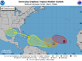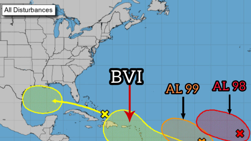
1. 𝗖𝗲𝗻𝘁𝗿𝗮𝗹 𝗧𝗿𝗼𝗽𝗶𝗰𝗮𝗹 𝗔𝘁𝗹𝗮𝗻𝘁𝗶𝗰 (𝗔𝗟𝟵𝟵): Disorganized showers and thunderstorms persist in association with an elongated trough of low pressure about 1000 miles west-southwest of the Cabo Verde Islands. Environmental conditions appear only marginally conducive for further development of this system, but a tropical depression could still form during the next several days while it moves west-northwestward at 10 to 15 mph across the central tropical Atlantic.
* Formation chance through 48 hours…medium…40 percent.
* Formation chance through 7 days…medium…50 percent.
2. 𝗘𝗮𝘀𝘁𝗲𝗿𝗻 𝗧𝗿𝗼𝗽𝗶𝗰𝗮𝗹 𝗔𝘁𝗹𝗮𝗻𝘁𝗶𝗰 (𝗔𝗟𝟵𝟴): Showers and thunderstorms have become a little better organized in association with a broad area of low pressure located a few hundred miles west of the Cabo Verde Islands. Over the next few days environmental conditions appears mostly favorable for additional development while it moves toward the west-northwest or northwest at
around 10 mph across the eastern tropical Atlantic, and a tropical
depression is likely to form over the weekend before environmental
conditions become unfavorable for development early next week.
* Formation chance through 48 hours…medium…50 percent.
* Formation chance through 7 days…high…70 percent.
3. 𝗘𝗮𝘀𝘁-𝗦𝗼𝘂𝘁𝗵𝗲𝗮𝘀𝘁 𝗼𝗳 𝘁𝗵𝗲 𝗟𝗲𝘀𝘀𝗲𝗿 𝗔𝗻𝘁𝗶𝗹𝗹𝗲𝘀 (𝗗𝗶𝘀𝘁𝘂𝗿𝗯𝗮𝗻𝗰𝗲) :Another area of low pressure could form in a day or so on the tail end of an elongated trough of low pressure, currently located more than 500 miles to the east-southeast of the Lesser Antilles. Some slow development of this system is possible over the weekend into early next week as it moves generally west-northwestward at 10-15 mph across the Lesser Antilles into the northeastern Caribbean Sea.
* Formation chance through 48 hours…low…10 percent.
* Formation chance through 7 days…low…20 percent.
Residents should monitor these systems closely and work to complete any seasonal preparations in case this system develops into a threat for the Virgin Islands.
𝗖𝗼𝗻𝘁𝗶𝗻𝘂𝗲 𝘁𝗼 𝗰𝗵𝗲𝗰𝗸 𝘁𝗵𝗲 𝗗𝗗𝗠 𝗮𝗽𝗽 , 𝗙𝗮𝗰𝗲𝗯𝗼𝗼𝗸, 𝗜𝗻𝘀𝘁𝗮𝗴𝗿𝗮𝗺, 𝗧𝘄𝗶𝘁𝘁𝗲𝗿 𝗽𝗮𝗴𝗲𝘀 𝗮𝗻𝗱 𝗼𝘂𝗿 𝘄𝗲𝗯𝘀𝗶𝘁𝗲 𝘄𝘄𝘄.𝗯𝘃𝗶𝗱𝗱𝗺.𝗰𝗼𝗺/ 𝗱𝗮𝗶𝗹𝘆 𝗳𝗼𝗿 𝘂𝗽𝗱𝗮𝘁𝗲𝘀
Disclaimer: The Department of Disaster Management (DDM) is not a Meteorological Office. Information shared by the Department is gathered from a number of professional sources contracted by the Department. This information should be used as a guide for anyone who has an interest in local weather conditions. By no means can DDM or the Government of the Virgin Islands be held accountable by anyone who uses this information appropriately for legal evidence or in justification of any decision, which may result in the loss of finances, property or life.