Forecaster Berg of the National Hurricane Center 5pm advisory.
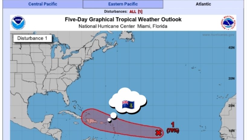
Satellite-derived wind data from this morning indicated that a small area of low pressure has developed along a tropical wave about 1200 miles east of the Lesser Antilles. However, the low does not quite have a closed circulation, and the associated shower and thunderstorm activity remains disorganized. Environmental conditions are expected to become more conducive for additional development, and a tropical depression is likely to form by the weekend while moving generally westward at about 20 mph across the tropical Atlantic. This system is expected to reach portions of the Leeward Islands late Saturday or early Sunday, and interests there should monitor its progress.
𝗔𝘁 𝘁𝗵𝗶𝘀 𝘁𝗶𝗺𝗲 𝘁𝗵𝗲𝗿𝗲 𝗮𝗿𝗲 𝗻𝗼 𝘄𝗮𝘁𝗰𝗵𝗲𝘀 𝗼𝗿 𝘄𝗮𝗿𝗻𝗶𝗻𝗴𝘀 𝗳𝗼𝗿 𝘁𝗵𝗲 𝗕𝗿𝗶𝘁𝗶𝘀𝗵 𝗩𝗶𝗿𝗴𝗶𝗻 𝗜𝘀𝗹𝗮𝗻𝗱𝘀. 𝗣𝗲𝗿𝘀𝗼𝗻𝘀 𝗺𝘂𝘀𝘁 𝗰𝗼𝗻𝘁𝗶𝗻𝘂𝗲 𝘁𝗼 𝗺𝗼𝗻𝗶𝘁𝗼𝗿 𝘁𝗵𝗲 𝗔𝘁𝗹𝗮𝗻𝘁𝗶𝗰 𝗶𝗻 𝗰𝗮𝘀𝗲 𝗼𝗳 𝗮𝗻𝘆 𝗰𝗵𝗮𝗻𝗴𝗲𝘀 𝘄𝗶𝘁𝗵 𝘁𝗵𝗲𝘀𝗲 𝘀𝘆𝘀𝘁𝗲𝗺𝘀.
𝗖𝗼𝗻𝘁𝗶𝗻𝘂𝗲 𝘁𝗼 𝗰𝗵𝗲𝗰𝗸 𝘁𝗵𝗲 𝗗𝗗𝗠 𝗮𝗽𝗽 , 𝗙𝗮𝗰𝗲𝗯𝗼𝗼𝗸, 𝗜𝗻𝘀𝘁𝗮𝗴𝗿𝗮𝗺, 𝗧𝘄𝗶𝘁𝘁𝗲𝗿 𝗽𝗮𝗴𝗲𝘀 𝗮𝗻𝗱 𝗼𝘂𝗿 𝘄𝗲𝗯𝘀𝗶𝘁𝗲 𝘄𝘄𝘄.𝗯𝘃𝗶𝗱𝗱𝗺.𝗰𝗼𝗺/ 𝗱𝗮𝗶𝗹𝘆 𝗳𝗼𝗿 𝘂𝗽𝗱𝗮𝘁𝗲𝘀.
Disclaimer: The Department of Disaster Management (DDM) is not an official Meteorological Office. The Information disseminated by the Department is gathered from a number of professional sources used or contracted by the DDM to provide such information. This information is to be used as a guide by anyone who has interest in local weather conditions. By no means can DDM or