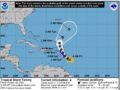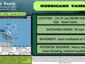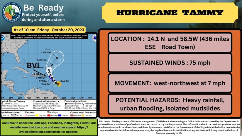
Hurricane Tammy Tropical Cyclone Update
NWS National Hurricane Center Miami FL       AL202023
1000 AM AST Fri Oct 20 2023

...TAMMY BECOMES A HURRICANE...

NOAA and Air Force Reserve hurricane hunter aircraft data indicate
that Tammy has become a hurricane. The maximum winds are estimated
to be 75 mph (120 km/h) with higher gusts.  The initial and forecast
intensities will be updated with the next advisory that will be
issued at 1100 AM AST (1500 UTC).

SUMMARY OF 1000 AM AST...1400 UTC...INFORMATION
-----------------------------------------------
LOCATION...14.1N 58.5W
ABOUT 90 MI...150 KM NE OF BARBADOS
ABOUT 170 MI...275 KM ESE OF MARTINIQUE
MAXIMUM SUSTAINED WINDS...75 MPH...120 KM/H
PRESENT MOVEMENT...WNW OR 290 DEGREES AT 7 MPH...11 KM/H
MINIMUM CENTRAL PRESSURE...992 MB...29.29 INCHES

$$
Forecaster Brown
𝗖𝗼𝗻𝘁𝗶𝗻𝘂𝗲 𝘁𝗼 𝗰𝗵𝗲𝗰𝗸 𝘁𝗵𝗲 𝗗𝗗𝗠 𝗮𝗽𝗽, 𝗙𝗮𝗰𝗲𝗯𝗼𝗼𝗸, 𝗜𝗻𝘀𝘁𝗮𝗴𝗿𝗮𝗺, 𝗧𝘄𝗶𝘁𝘁𝗲𝗿, 𝗼𝘂𝗿 𝘄𝗲𝗯𝘀𝗶𝘁𝗲 𝘄𝘄𝘄.𝗯𝘃𝗶𝗱𝗱𝗺.𝗰𝗼𝗺 𝗮𝗻𝗱 𝘄𝗲𝗮𝘁𝗵𝗲𝗿 𝘀𝘁𝗲𝗺 𝗮𝘁 𝗵𝘁𝘁𝗽𝘀://𝗯𝘃𝗶.𝘄𝗲𝗮𝘁𝗵𝗲𝗿𝘀𝘁𝗲𝗺.𝗰𝗼𝗺/𝘁𝗼𝗿𝘁𝗼𝗹𝗮 𝗳𝗼𝗿 𝘂𝗽𝗱𝗮𝘁𝗲𝘀..
Here are the links for our BVIDDM EMERGENCY APP
Disclaimer: The Department of Disaster Management (DDM) is not a Meteorological Office. Information shared by the Department is gathered from a number of professional sources contracted by the Department. This information should be used as a guide for anyone who has an interest in local weather conditions. By no means can DDM or the Government of the Virgin Islands be held accountable by anyone who uses this information appropriately for legal evidence or in justification of any decision which may result in the loss of finances, property or life.