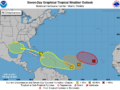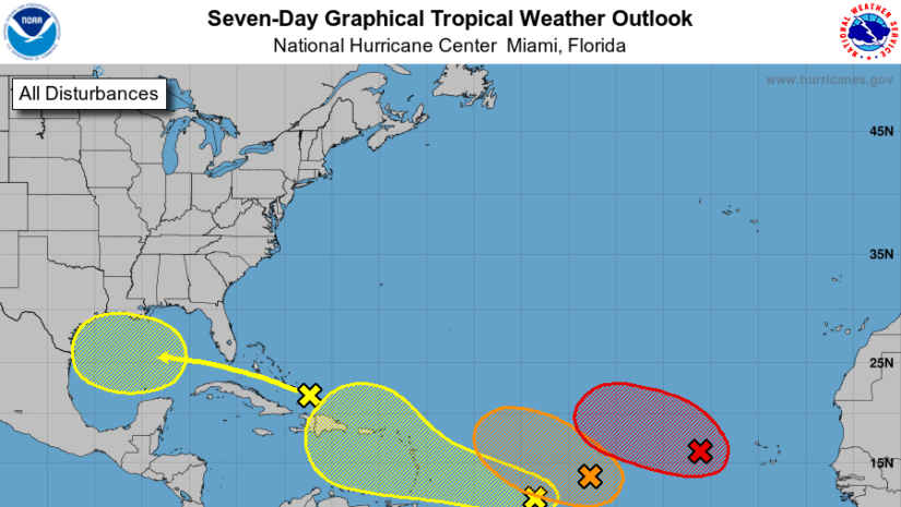
Tropical Weather Outlook
NWS National Hurricane Center Miami FL
800 AM EDT Fri Aug 18 2023

For the North Atlantic...Caribbean Sea and the Gulf of Mexico:

1. Eastern Tropical Atlantic (AL98):
Showers and thunderstorms continue to show some signs of
organization in association with a broad area of low pressure
located a few hundred miles west of the Cabo Verde Islands.
Environmental conditions appear generally favorable for additional
development of this system, and a tropical depression is likely to
form over the weekend while it moves toward the west-northwest or
northwest at about 10 mph across the eastern tropical Atlantic. By
early next week, upper-level winds over the system are forecast to
increase, and further development is not expected.
* Formation chance through 48 hours...medium...60 percent.
* Formation chance through 7 days...high...70 percent.

2. Central Tropical Atlantic (AL99):
An elongated trough of low pressure located roughly halfway between
the Cabo Verde Islands and the Lesser Antilles is producing some
disorganized showers and thunderstorms. Environmental conditions are
only marginally conducive for further development of this system,
but a tropical depression could still form during the next couple of
days while it moves west-northwestward at 10 to 15 mph across the
central tropical Atlantic. Thereafter, upper-level winds are
forecast to become unfavorable for any further development.
* Formation chance through 48 hours...medium...40 percent.
* Formation chance through 7 days...medium...40 percent.

3. East-Southeast of the Lesser Antilles:
Another area of low pressure could form in a day or so from an
elongated trough of low pressure located several hundred miles to
the east-southeast of the Lesser Antilles. Some slow development of
this system is possible over the weekend and into early next week
as it moves generally west-northwestward at 10 to 15 mph across the
Lesser Antilles and into the northeastern Caribbean Sea.
* Formation chance through 48 hours...low...10 percent.
* Formation chance through 7 days...low...30 percent.
Forecaster Bucci/Hagen
𝘿𝙞𝙨𝙘𝙡𝙖𝙞𝙢𝙚𝙧: 𝙏𝙝𝙚 𝘿𝙚𝙥𝙖𝙧𝙩𝙢𝙚𝙣𝙩 𝙤𝙛 𝘿𝙞𝙨𝙖𝙨𝙩𝙚𝙧 𝙈𝙖𝙣𝙖𝙜𝙚𝙢𝙚𝙣𝙩 (𝘿𝘿𝙈) 𝙞𝙨 𝙣𝙤𝙩 𝙖𝙣 𝙤𝙛𝙛𝙞𝙘𝙞𝙖𝙡 𝙈𝙚𝙩𝙚𝙤𝙧𝙤𝙡𝙤𝙜𝙞𝙘𝙖𝙡 𝙊𝙛𝙛𝙞𝙘𝙚. 𝙏𝙝𝙚 𝙄𝙣𝙛𝙤𝙧𝙢𝙖𝙩𝙞𝙤𝙣 𝙙𝙞𝙨𝙨𝙚𝙢𝙞𝙣𝙖𝙩𝙚𝙙 𝙗𝙮 𝙩𝙝𝙚 𝘿𝙚𝙥𝙖𝙧𝙩𝙢𝙚𝙣𝙩 𝙞𝙨 𝙜𝙖𝙩𝙝𝙚𝙧𝙚𝙙 𝙛𝙧𝙤𝙢 𝙖 𝙣𝙪𝙢𝙗𝙚𝙧 𝙤𝙛 𝙥𝙧𝙤𝙛𝙚𝙨𝙨𝙞𝙤𝙣𝙖𝙡 𝙨𝙤𝙪𝙧𝙘𝙚𝙨 𝙪𝙨𝙚𝙙 𝙤𝙧 𝙘𝙤𝙣𝙩𝙧𝙖𝙘𝙩𝙚𝙙 𝙗𝙮 𝙩𝙝𝙚 𝘿𝘿𝙈 𝙩𝙤 𝙞𝙢𝙥𝙧𝙤𝙫𝙞𝙙𝙚 𝙨𝙪𝙘𝙝 𝙞𝙣𝙛𝙤𝙧𝙢𝙖𝙩𝙞𝙤𝙣. 𝙏𝙝𝙞𝙨 𝙞𝙣𝙛𝙤𝙧𝙢𝙖𝙩𝙞𝙤𝙣 𝙞𝙨 𝙩𝙤 𝙗𝙚 𝙪𝙨𝙚𝙙 𝙖𝙨 𝙖 𝙜𝙪𝙞𝙙𝙚 𝙗𝙮 𝙖𝙣𝙮𝙤𝙣𝙚 𝙬𝙝𝙤 𝙝𝙖𝙨 𝙞𝙣𝙩𝙚𝙧𝙚𝙨𝙩 𝙞𝙣 𝙡𝙤𝙘𝙖𝙡 𝙬𝙚𝙖𝙩𝙝𝙚𝙧 𝙘𝙤𝙣𝙙𝙞𝙩𝙞𝙤𝙣𝙨. 𝘽𝙮 𝙣𝙤 𝙢𝙚𝙖𝙣𝙨 𝙘𝙖𝙣 𝘿𝘿𝙈 𝙤𝙧 𝙩𝙝𝙚 𝘽𝙑𝙄 𝙂𝙤𝙫𝙚𝙧𝙣𝙢𝙚𝙣𝙩 𝙗𝙚 𝙝𝙚𝙡𝙙 𝙖𝙘𝙘𝙤𝙪𝙣𝙩𝙖𝙗𝙡𝙚 𝙗𝙮 𝙖𝙣𝙮𝙤𝙣𝙚 𝙬𝙝𝙤 𝙪𝙨𝙚𝙨 𝙩𝙝𝙞𝙨 𝙞𝙣𝙛𝙤𝙧𝙢𝙖𝙩𝙞𝙤𝙣 𝙖𝙥𝙥𝙧𝙤𝙥𝙧𝙞𝙖𝙩𝙚𝙡𝙮 𝙛𝙤𝙧 𝙡𝙚𝙜𝙖𝙡 𝙚𝙫𝙞𝙙𝙚𝙣𝙘𝙚 𝙤𝙧 𝙞𝙣 𝙟𝙪𝙨𝙩𝙞𝙛𝙞𝙘𝙖𝙩𝙞𝙤𝙣 𝙤𝙛 𝙖𝙣𝙮 𝙙𝙚𝙘𝙞𝙨𝙞𝙤𝙣 𝙬𝙝𝙞𝙘𝙝 𝙢𝙖𝙮 𝙧𝙚𝙨𝙪𝙡𝙩 𝙞𝙣 𝙩𝙝𝙚 𝙡𝙤𝙨𝙨 𝙤𝙛 𝙛𝙞𝙣𝙖𝙣𝙘𝙚𝙨, 𝙥𝙧𝙤𝙥𝙚𝙧𝙩𝙮 𝙤𝙧 𝙡𝙞𝙛𝙚.