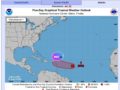
close
Tropical Wave Update

Tropical Wave Update

August 13, 2021505Views

…๐ƒ๐ˆ๐’๐“๐”๐‘๐๐€๐๐‚๐„ ๐Ž๐•๐„๐‘ ๐“๐‡๐„ ๐‚๐„๐๐“๐‘๐€๐‹ ๐“๐‘๐Ž๐๐ˆ๐‚๐€๐‹ ๐€๐“๐‹๐€๐๐“๐ˆ๐‚ ๐„๐—๐๐„๐‚๐“๐„๐ƒ ๐“๐Ž ๐๐„๐‚๐Ž๐Œ๐„ ๐€ ๐“๐‘๐Ž๐๐ˆ๐‚๐€๐‹ ๐’๐“๐Ž๐‘๐Œ ๐๐˜ ๐’๐€๐“๐”๐‘๐ƒ๐€๐˜…๐“๐‘๐Ž๐๐ˆ๐‚๐€๐‹ ๐’๐“๐Ž๐‘๐Œ ๐–๐€๐“๐‚๐‡๐„๐’ ๐ˆ๐’๐’๐”๐„๐ƒ ๐…๐Ž๐‘ ๐€ ๐๐Ž๐‘๐“๐ˆ๐Ž๐ ๐Ž๐… ๐“๐‡๐„ ๐‹๐„๐„๐–๐€๐‘๐ƒ๐ˆ๐’๐‹๐€๐๐ƒ๐’…

SUMMARY OF 1100 AM AST…1500 UTC…INFORMATION———————————————–

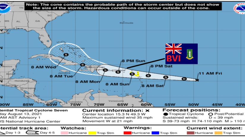
LOCATION…15.3N 49.3W

ABOUT 840 MILES…1350 KM E OF THE LEEWARD ISLANDS

ABOUT 883 MILESโ€ฆ1421 KM E OF ROAD TOWN

MAXIMUM SUSTAINED WINDS…35 MPH…55 KM/

PRESENT MOVEMENT…W OR 280 DEGREES AT 21 MPH…33 KM/

MINIMUM CENTRAL PRESSURE…1010 MB…29.83 INCHES

WATCHES AND WARNINGS——————–CHANGES WITH THIS ADVISORY:

๐“๐ก๐ž ๐ ๐จ๐ฏ๐ž๐ซ๐ง๐ฆ๐ž๐ง๐ญ ๐จ๐Ÿ ๐€๐ง๐ญ๐ข๐ ๐ฎ๐š ๐š๐ง๐ ๐๐š๐ซ๐›๐ฎ๐๐š ๐ก๐š๐ฌ ๐ข๐ฌ๐ฌ๐ฎ๐ž๐ ๐š ๐“๐ซ๐จ๐ฉ๐ข๐œ๐š๐ฅ ๐’๐ญ๐จ๐ซ๐ฆ๐–๐š๐ญ๐œ๐ก ๐Ÿ๐จ๐ซ ๐€๐ง๐ญ๐ข๐ ๐ฎ๐š ๐š๐ง๐ ๐๐š๐ซ๐›๐ฎ๐๐š, ๐’๐ญ. ๐Š๐ข๐ญ๐ญ๐ฌ ๐š๐ง๐ ๐๐ž๐ฏ๐ข๐ฌ, ๐š๐ง๐ ๐Œ๐จ๐ง๐ญ๐ฌ๐ž๐ซ๐ซ๐š๐ญ.

๐“๐ก๐ž ๐ ๐จ๐ฏ๐ž๐ซ๐ง๐ฆ๐ž๐ง๐ญ ๐จ๐Ÿ ๐ญ๐ก๐ž ๐๐ž๐ญ๐ก๐ž๐ซ๐ฅ๐š๐ง๐๐ฌ ๐ก๐š๐ฌ ๐ข๐ฌ๐ฌ๐ฎ๐ž๐ ๐š ๐“๐ซ๐จ๐ฉ๐ข๐œ๐š๐ฅ ๐’๐ญ๐จ๐ซ๐ฆ ๐–๐š๐ญ๐œ๐ก ๐Ÿ๐จ๐ซ ๐’๐š๐›๐š ๐š๐ง๐ ๐’๐ข๐ง๐ญ ๐„๐ฎ๐ฌ๐ญ๐š๐ญ๐ข๐ฎ๐ฌ.


SUMMARY OF WATCHES AND WARNINGS IN EFFECT:

A Tropical Storm Watch means that tropical storm conditions are possible within the watch area, generally within 48 hours. Interests elsewhere in the Leeward Islands, the Virgin Islands, British Virgin Islands, Puerto Rico should monitor the progress of this system.ย  Tropical Storm Watches will possibly be required for these areas later today or tonight.

DISCUSSION AND OUTLOOK———————-

The disturbance was centered near latitude 15.3 North, longitude 49.3 West.ย  The system is moving toward the west near 21 mph (33 km/h), and this general motion with a gradual decrease in forward speed is expected into early next week.ย  On the forecast track, the system is expected to approach the Leeward Islands on Saturday, move over the Leeward Islands Saturday night and Sunday, and then be near the Virgin Islands and Puerto Rico Sunday night and Monday. Maximum sustained winds are near 35 mph (55 km/h) with higher gusts. Gradual strengthening is forecast during the next couple of days,ย  and the disturbance is expected to become a tropical depression tonight and a tropical storm by Saturday.

* Formation chance through 48 hours…high…80 percent.

* Formation chance through 5 days…high…80 percent.

The estimated minimum central pressure is 1010 mb (29.83 inches).


๐—–๐—ผ๐—ป๐˜๐—ถ๐—ป๐˜‚๐—ฒ ๐˜๐—ผ ๐—ฐ๐—ต๐—ฒ๐—ฐ๐—ธ ๐˜๐—ต๐—ฒ ๐——๐——๐—  ๐—ฎ๐—ฝ๐—ฝ , ๐—™๐—ฎ๐—ฐ๐—ฒ๐—ฏ๐—ผ๐—ผ๐—ธ, ๐—œ๐—ป๐˜€๐˜๐—ฎ๐—ด๐—ฟ๐—ฎ๐—บ, ๐—ง๐˜„๐—ถ๐˜๐˜๐—ฒ๐—ฟ ๐—ฝ๐—ฎ๐—ด๐—ฒ๐˜€ ๐—ฎ๐—ป๐—ฑ ๐—ผ๐˜‚๐—ฟ ๐˜„๐—ฒ๐—ฏ๐˜€๐—ถ๐˜๐—ฒ ๐˜„๐˜„๐˜„.๐—ฏ๐˜ƒ๐—ถ๐—ฑ๐—ฑ๐—บ.๐—ฐ๐—ผ๐—บ/ ๐—ฑ๐—ฎ๐—ถ๐—น๐˜† ๐—ณ๐—ผ๐—ฟ ๐˜‚๐—ฝ๐—ฑ๐—ฎ๐˜๐—ฒ๐˜€.


๐˜ฟ๐™ž๐™จ๐™˜๐™ก๐™–๐™ž๐™ข๐™š๐™ง: ๐™๐™๐™š ๐˜ฟ๐™š๐™ฅ๐™–๐™ง๐™ฉ๐™ข๐™š๐™ฃ๐™ฉ ๐™ค๐™› ๐˜ฟ๐™ž๐™จ๐™–๐™จ๐™ฉ๐™š๐™ง ๐™ˆ๐™–๐™ฃ๐™–๐™œ๐™š๐™ข๐™š๐™ฃ๐™ฉ (๐˜ฟ๐˜ฟ๐™ˆ) ๐™ž๐™จ ๐™ฃ๐™ค๐™ฉ ๐™–๐™ฃ ๐™ค๐™›๐™›๐™ž๐™˜๐™ž๐™–๐™ก ๐™ˆ๐™š๐™ฉ๐™š๐™ค๐™ง๐™ค๐™ก๐™ค๐™œ๐™ž๐™˜๐™–๐™ก ๐™Š๐™›๐™›๐™ž๐™˜๐™š. ๐™๐™๐™š ๐™„๐™ฃ๐™›๐™ค๐™ง๐™ข๐™–๐™ฉ๐™ž๐™ค๐™ฃ ๐™™๐™ž๐™จ๐™จ๐™š๐™ข๐™ž๐™ฃ๐™–๐™ฉ๐™š๐™™ ๐™—๐™ฎ ๐™ฉ๐™๐™š ๐˜ฟ๐™š๐™ฅ๐™–๐™ง๐™ฉ๐™ข๐™š๐™ฃ๐™ฉ ๐™ž๐™จ ๐™œ๐™–๐™ฉ๐™๐™š๐™ง๐™š๐™™ ๐™›๐™ง๐™ค๐™ข ๐™– ๐™ฃ๐™ช๐™ข๐™—๐™š๐™ง ๐™ค๐™› ๐™ฅ๐™ง๐™ค๐™›๐™š๐™จ๐™จ๐™ž๐™ค๐™ฃ๐™–๐™ก ๐™จ๐™ค๐™ช๐™ง๐™˜๐™š๐™จ ๐™ช๐™จ๐™š๐™™ ๐™ค๐™ง ๐™˜๐™ค๐™ฃ๐™ฉ๐™ง๐™–๐™˜๐™ฉ๐™š๐™™ ๐™—๐™ฎ ๐™ฉ๐™๐™š ๐˜ฟ๐˜ฟ๐™ˆ ๐™ฉ๐™ค ๐™ž๐™ข๐™ฅ๐™ง๐™ค๐™ซ๐™ž๐™™๐™š ๐™จ๐™ช๐™˜๐™ ๐™ž๐™ฃ๐™›๐™ค๐™ง๐™ข๐™–๐™ฉ๐™ž๐™ค๐™ฃ. ๐™๐™๐™ž๐™จ ๐™ž๐™ฃ๐™›๐™ค๐™ง๐™ข๐™–๐™ฉ๐™ž๐™ค๐™ฃ ๐™ž๐™จ ๐™ฉ๐™ค ๐™—๐™š ๐™ช๐™จ๐™š๐™™ ๐™–๐™จ ๐™– ๐™œ๐™ช๐™ž๐™™๐™š ๐™—๐™ฎ ๐™–๐™ฃ๐™ฎ๐™ค๐™ฃ๐™š ๐™ฌ๐™๐™ค ๐™๐™–๐™จ ๐™ž๐™ฃ๐™ฉ๐™š๐™ง๐™š๐™จ๐™ฉ ๐™ž๐™ฃ ๐™ก๐™ค๐™˜๐™–๐™ก ๐™ฌ๐™š๐™–๐™ฉ๐™๐™š๐™ง ๐™˜๐™ค๐™ฃ๐™™๐™ž๐™ฉ๐™ž๐™ค๐™ฃ๐™จ. ๐˜ฝ๐™ฎ ๐™ฃ๐™ค ๐™ข๐™š๐™–๐™ฃ๐™จ ๐™˜๐™–๐™ฃย  ๐˜ฟ๐˜ฟ๐™ˆ ๐™ค๐™ง ๐™ฉ๐™๐™š ๐˜ฝ๐™‘๐™„ ๐™‚๐™ค๐™ซ๐™š๐™ง๐™ฃ๐™ข๐™š๐™ฃ๐™ฉ ๐™—๐™š ๐™๐™š๐™ก๐™™ ๐™–๐™˜๐™˜๐™ค๐™ช๐™ฃ๐™ฉ๐™–๐™—๐™ก๐™š ๐™—๐™ฎ ๐™–๐™ฃ๐™ฎ๐™ค๐™ฃ๐™š ๐™ฌ๐™๐™ค ๐™ช๐™จ๐™š๐™จ ๐™ฉ๐™๐™ž๐™จ ๐™ž๐™ฃ๐™›๐™ค๐™ง๐™ข๐™–๐™ฉ๐™ž๐™ค๐™ฃ ๐™–๐™ฅ๐™ฅ๐™ง๐™ค๐™ฅ๐™ง๐™ž๐™–๐™ฉ๐™š๐™ก๐™ฎ ๐™›๐™ค๐™ง ๐™ก๐™š๐™œ๐™–๐™ก ๐™š๐™ซ๐™ž๐™™๐™š๐™ฃ๐™˜๐™š ๐™ค๐™ง ๐™ž๐™ฃ ๐™Ÿ๐™ช๐™จ๐™ฉ๐™ž๐™›๐™ž๐™˜๐™–๐™ฉ๐™ž๐™ค๐™ฃ ๐™ค๐™› ๐™–๐™ฃ๐™ฎ ๐™™๐™š๐™˜๐™ž๐™จ๐™ž๐™ค๐™ฃ ๐™ฌ๐™๐™ž๐™˜๐™ ๐™ข๐™–๐™ฎ ๐™ง๐™š๐™จ๐™ช๐™ก๐™ฉ ๐™ž๐™ฃ ๐™ฉ๐™๐™š ๐™ก๐™ค๐™จ๐™จ ๐™ค๐™› ๐™›๐™ž๐™ฃ๐™–๐™ฃ๐™˜๐™š๐™จ, ๐™ฅ๐™ง๐™ค๐™ฅ๐™š๐™ง๐™ฉ๐™ฎ ๐™ค๐™ง ๐™ก๐™ž๐™›๐™š..