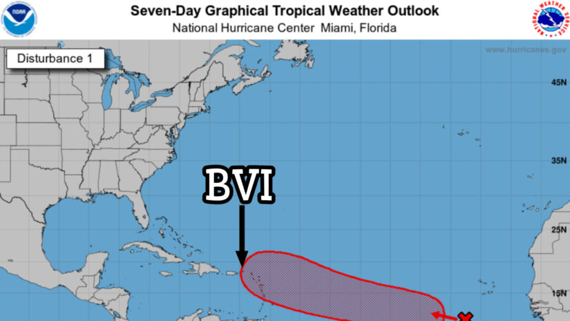
Disturbance AL95 is becoming better defined today near 10.5N, 25.0W, or about 300 miles south of the Cabo Verde Islands which is estimated 2346 miles ESE of the BVI.
The disturbance continues to move westward at 10 mph. It is forecast to track to the west-northwest next week. It could develop into a tropical storm by late Tuesday or Wednesday midway between the Cabo Verde Islands and Lesser Antilles, then pass to the northeast of the northern Leeward islands to Puerto Rico by Saturday and next Sunday as a hurricane.
The chance of tropical development is estimated at 40 percent within the next 48 hours, then 80 percent chance within the next week.
Meteorologists: Claude Aultman / Amanda Lyles
We will keep monitoring and bring updates as conditions change.
𝗖𝗼𝗻𝘁𝗶𝗻𝘂𝗲 𝘁𝗼 𝗰𝗵𝗲𝗰𝗸 𝘁𝗵𝗲 𝗗𝗗𝗠 𝗮𝗽𝗽 , 𝗙𝗮𝗰𝗲𝗯𝗼𝗼𝗸, 𝗜𝗻𝘀𝘁𝗮𝗴𝗿𝗮𝗺, 𝗧𝘄𝗶𝘁𝘁𝗲𝗿 𝗽𝗮𝗴𝗲𝘀 𝗮𝗻𝗱 𝗼𝘂𝗿 𝘄𝗲𝗯𝘀𝗶𝘁𝗲 𝘄𝘄𝘄.𝗯𝘃𝗶𝗱𝗱𝗺.𝗰𝗼𝗺/ 𝗱𝗮𝗶𝗹𝘆 𝗳𝗼𝗿 𝘂𝗽𝗱𝗮𝘁𝗲𝘀
Disclaimer: The Department of Disaster Management (DDM) is not a Meteorological Office. Information shared by the Department is gathered from a number of professional sources contracted by the Department. This information should be used as a guide for anyone who has an interest in local weather conditions. By no means can DDM or the Government of the Virgin Islands be held accountable by anyone who uses this information appropriately for legal evidence or in justification of any decision, which may result in the loss of finances, property or life.