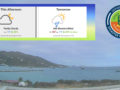
Synopsis: A relatively strong Atlantic High Pressure system will continue to generate a moderate to fresh trade wind flow across the area during the next 24 hours. Additionally, pockets of low level moisture embedded within this flow will continue to be transported across the area and maintain a heightened chance for shower activity over and around the islands during that time.
Weather today: Partly sunny skies, with brief cloudy spells and a 60 percent or moderate chance of brief passing showers.
Weather tonight: Partly cloudy to cloudy skies with a 70 percent or high chance of overnight showers.
Winds: East at 15 to 30 km/h or 9 to 18 mph, reaching as high as 44 km/h or 28 mph during showers as well as over open waters and in elevated areas.
Seas: 1.8 to 2.4 metres or 6 to 8 feet. Therefore a small craft advisory remains in effect.
Sunset today: 6:14 pm.
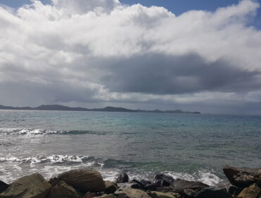
Photo Credit: Alton ABX Bertie
For more weather information you can visit the Department of Disaster Management WeatherStem Station on the link provided. http://bvi.weatherstem.com/tortola
𝗖𝗼𝗻𝘁𝗶𝗻𝘂𝗲 𝘁𝗼 𝗰𝗵𝗲𝗰𝗸 𝘁𝗵𝗲 𝗗𝗗𝗠 𝗮𝗽𝗽, 𝗙𝗮𝗰𝗲𝗯𝗼𝗼𝗸, 𝗜𝗻𝘀𝘁𝗮𝗴𝗿𝗮𝗺, 𝗧𝘄𝗶𝘁𝘁𝗲𝗿 𝗮𝗻𝗱 𝗼𝘂𝗿 𝘄𝗲𝗯𝘀𝗶𝘁𝗲 𝘄𝘄𝘄.𝗯𝘃𝗶𝗱𝗱𝗺.𝗰𝗼𝗺 𝗳𝗼𝗿 𝘂𝗽𝗱𝗮𝘁𝗲𝘀.
Disclaimer: The Department of Disaster Management (DDM) is not a Meteorological Office. Information shared by the Department is gathered from a number of professional sources contracted by the Department. This information should be used as a guide for anyone who has an interest in local weather conditions. By no means can DDM or the Government of the Virgin Islands be held accountable by anyone who uses this information appropriately for legal evidence or in justification of any decision which may result in the loss of finances, property or life.