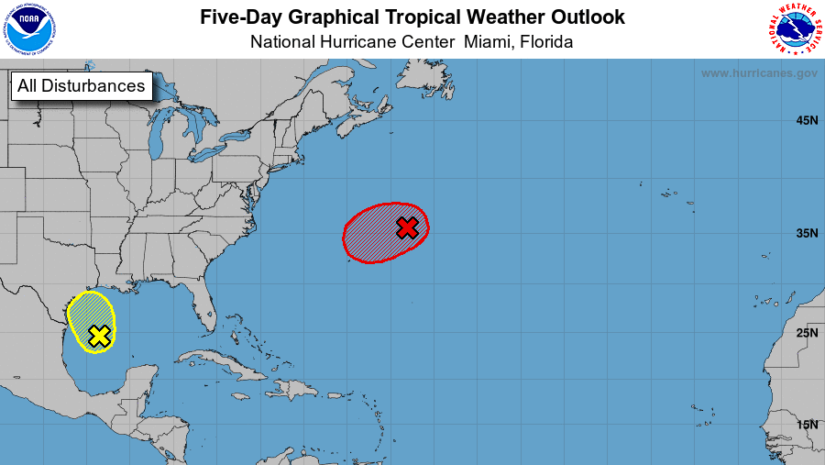
Disturbance [1] According to the National Hurricane Centre at 2am May 21,2021 A non-tropical low-pressure area located about 500 miles east-northeast of Bermuda is producing winds to storm force and disorganized showers and thunderstorms. The low is expected to move west-southwestward over warmer waters during the next day or so, and it will likely become a subtropical cyclone later today or on Saturday near or to the northeast of Bermuda. Thereafter, the low is forecast to move northeastward into a more hostile environment by Saturday night or Sunday.
Disturbance [2] According to the National Hurricane Centre at 2am May 21,2021 A surface trough and a mid- to upper-level disturbance over the western Gulf of Mexico are producing disorganized showers and thunderstorms. Environmental conditions are expected to be marginally conducive for development before the disturbance moves inland over the northwestern Gulf coast tonight. Regardless of development, the system could produce heavy rainfall over portions of southeastern Texas and southwestern Louisiana during the next few days.
Disclaimer: The Department of Disaster Management (DDM) is not an official Meteorological Office. The Information disseminated by the Department is gathered from a number of professional sources used or contracted by the DDM to provide such information. This information is to be used as a guide by anyone who has interest in local weather conditions. By no means can the DDM or the BVI Government be held accountable by anyone who uses this information appropriately for legal evidence or in justification of any decision which may result in the loss of finances, property or life.