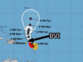
At 5:00 a.m., the centre of Hurricane Tammy was located at 18.5N, 62.3W or 131 miles east of Road Town. The Virgin Islands is no longer under a Tropical Storm Watch, however, the Territory may continue to experience disturbed weather in the coming days. A small craft warning remains in effect.
See below for the NHC discussion & outlook:
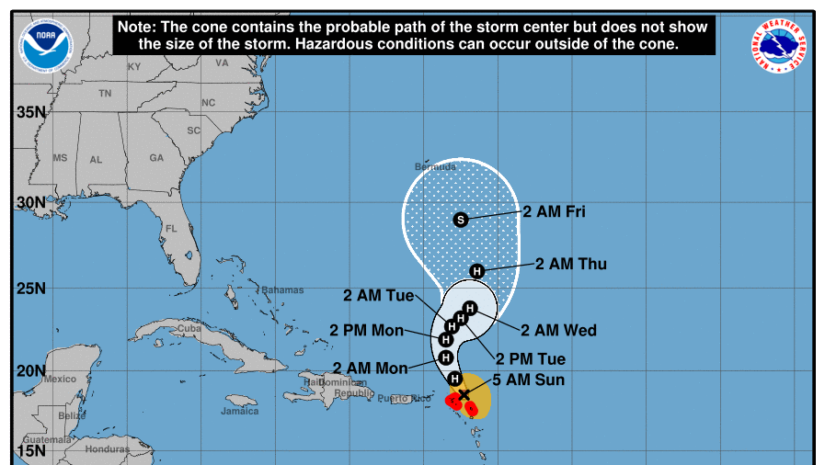
DISCUSSION AND OUTLOOK
----------------------
At 500 AM AST (0900 UTC), the center of Hurricane Tammy was located
near latitude 18.5 North, longitude 62.3 West. Tammy is moving
toward the north-northwest near 10 mph (17 km/h) and this general
motion is expected through today, followed by a turn toward the
north or north-northeast on Monday.  On the forecast track, the
center of Tammy will move further away from the northernmost Leeward
Islands later today.

Maximum sustained winds are near 85 mph (140 km/h) with higher
gusts. Some strengthening is possible today followed by fluctuations
in strength thereafter.

Hurricane-force winds extend outward up to 25 miles (35 km) from the
center and tropical-storm-force winds extend outward up to 140 miles
(220 km).

The estimated minimum central pressure is 992 mb (29.30 inches).


HAZARDS AFFECTING LAND
----------------------
Key messages for Tammy can be found in the Tropical Cyclone
Discussion under AWIPS header MIATCDAT5 and WMO header WTNT45 KNHC
and on the web at hurricanes.gov/text/MIATCDAT5.shtml

WIND:  Hurricane conditions are expected over portions of the
northernmost Leeward Islands for the next few hours.

RAINFALL: Tammy is expected to produce the following storm total
rainfall:

Leeward Islands: 4 to 8 inches with storm total maximum amounts of
12 inches

Martinique and Dominica: An additional 2 to 4 inches, with storm
total maximum of 6 inches

British and U.S. Virgin Islands into eastern Puerto Rico: 1 to 2
inches with maximum storm total amounts of 4 inches

These rains may produce isolated flash and urban flooding, along
with isolated mudslides in areas of higher terrain.

STORM SURGE:  Storm surge could raise water levels by as much as 1
to 3 feet above normal tide levels near where the center of Tammy
moves across the Leeward Islands.  Near the coast, the surge will
be accompanied by large and dangerous waves.

SURF:  Swells generated by Tammy will continue to affect portions of
the Lesser Antilles during the next few days.  These swells are
likely to cause life-threatening surf and rip current conditions.
Please consult products from your local weather office.