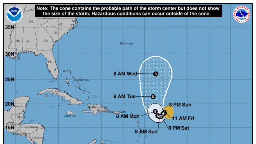
BULLETIN
Tropical Storm Philippe Advisory Number  33
NWS National Hurricane Center Miami FL       AL172023
1100 AM AST Sun Oct 01 2023

...TRACK OF PHILIPPE SHIFTING WESTWARD SO TROPICAL STORM WATCHES
ISSUED FOR ANTIGUA AND BARBUDA...


SUMMARY OF 1100 AM AST...1500 UTC...INFORMATION
-----------------------------------------------
LOCATION...16.1N 58.7W
ABOUT 180 MI...290 KM E OF GUADELOUPE
ABOUT 230 MI...370 KM ESE OF BARBUDA
MAXIMUM SUSTAINED WINDS...50 MPH...85 KM/H
PRESENT MOVEMENT...W OR 280 DEGREES AT 7 MPH...11 KM/H
MINIMUM CENTRAL PRESSURE...1002 MB...29.59 INCHES


WATCHES AND WARNINGS
--------------------
CHANGES WITH THIS ADVISORY:

The government of Antigua has issued a Tropical Storm for Antigua
and Barbuda.

SUMMARY OF WATCHES AND WARNINGS IN EFFECT:

A Tropical Storm Watch is in effect for...
* Antigua, Barbuda

Interests elsewhere in the northern Leeward Islands should monitor
the progress of this system.  Additional tropical storm watches or
warnings may be required later today.

For storm information specific to your area, please monitor
products issued by your national meteorological service.


DISCUSSION AND OUTLOOK
----------------------
At 1100 AM AST (1500 UTC), the center of Tropical Storm Philippe was
located near latitude 16.1 North, longitude 58.7 West. Philippe is
moving toward the west near 7 mph (11 km/h). A west-northwestward
to northwestward motion is expected to begin today and continue
into tonight.  A turn toward the northwest with an increase in
forward speed is expected on Monday, followed by a northward
motion on Tuesday.  On the forecast track, the center of Philippe
is forecast to pass near or just northeast of the northern Leeward
Islands on Monday and Monday night.

Maximum sustained winds remain near 50 mph (85 km/h) with higher
gusts. Little change in strength is forecast during the next 48
hours, and Philippe could begin to intensify more significantly
around the middle of the week.

Tropical-storm-force winds extend outward up to 170 miles (275 km),
primarily east of the center.

The estimated minimum central pressure is 1002 mb (29.59 inches)
based on dropsonde data from an Air Force Reserve Hurricane Hunter
aircraft.


HAZARDS AFFECTING LAND
----------------------
Key messages for Philippe can be found in the Tropical Cyclone
Discussion under AWIPS header MIATCDAT2 and WMO header WTNT42 KNHC
and on the web at hurricanes.gov/text/MIATCDAT2.shtml

RAINFALL:  Philippe is forecast to produce the following rainfall
amounts through Tuesday:

Barbuda and Antigua: 4 to 6 inches
Rest of Leeward Islands: 2 to 4 inches

This rainfall may result in isolated to scattered flash flooding.

WIND:  Tropical storm conditions are possible in the watch areas by
Monday morning.

SURF:  Swells generated by Philippe will affect portions of the
Atlantic coasts of the northern Leeward Islands, the Virgin
Islands, and Puerto Rico during the next few days. These swells are
likely to cause life-threatening surf and rip current conditions.
Please consult products from your local weather office.


NEXT ADVISORY
-------------
Next intermediate advisory at 200 PM AST.
Next complete advisory at 500 PM AST.

$$
Forecaster Blake
𝗖𝗼𝗻𝘁𝗶𝗻𝘂𝗲 𝘁𝗼 𝗰𝗵𝗲𝗰𝗸 𝘁𝗵𝗲 𝗗𝗗𝗠 𝗮𝗽𝗽, 𝗙𝗮𝗰𝗲𝗯𝗼𝗼𝗸, 𝗜𝗻𝘀𝘁𝗮𝗴𝗿𝗮𝗺, 𝗧𝘄𝗶𝘁𝘁𝗲𝗿, 𝗼𝘂𝗿 𝘄𝗲𝗯𝘀𝗶𝘁𝗲 𝘄𝘄𝘄.𝗯𝘃𝗶𝗱𝗱𝗺.𝗰𝗼𝗺 𝗮𝗻𝗱 𝘄𝗲𝗮𝘁𝗵𝗲𝗿 𝘀𝘁𝗲𝗺 𝗮𝘁 𝗵𝘁𝘁𝗽𝘀://𝗯𝘃𝗶.𝘄𝗲𝗮𝘁𝗵𝗲𝗿𝘀𝘁𝗲𝗺.𝗰𝗼𝗺/𝘁𝗼𝗿𝘁𝗼𝗹𝗮 𝗳𝗼𝗿 𝘂𝗽𝗱𝗮𝘁𝗲𝘀..
Here are the links for our BVIDDM EMERGENCY APP
Disclaimer: The Department of Disaster Management (DDM) is not a Meteorological Office. Information shared by the Department is gathered from a number of professional sources contracted by the Department. This information should be used as a guide for anyone who has an interest in local weather conditions. By no means can DDM or the Government of the Virgin Islands be held accountable by anyone who uses this information appropriately for legal evidence or in justification of any decision which may result in the loss of finances, property or life