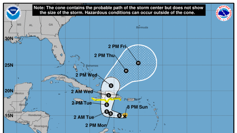
At 800 PM AST (0000 UTC), the center of Tropical Storm Franklin was located near latitude 14.8 North, longitude 67.8 West which is estimated at 283 miles South-Southwest of the BVI.
Moisture and instability associated with an area of disturbed weather, Tropical Storm Franklin located south of the BVI is forecast to generate unsettled conditions over the next few hours.
Franklin is moving toward the west-northwest near 14 mph (22 km/h). A west-northwestward track is expected to continue for the next day or so followed by a sharp turn to the north. On the forecast track, Franklin should approach the southern coast of Hispaniola on Tuesday.
Data from NOAA reconnaissance aircraft indicate that the maximum sustained winds are near 45 mph (75 km/h) with higher gusts. Some strengthening is forecast during the next 48 hours.
Tropical-storm-force winds extend outward up to 60 miles (95 km) from the center.
The minimum central pressure measured by NOAA reconnaissance aircraft is 1001 mb (29.56 inches)
WATCHES AND WARNINGS
CHANGES WITH THIS ADVISORY
A Flash Flood watch have been issued for the BVI Until Tommorow.
𝗙𝗹𝗼𝗼𝗱 𝗪𝗮𝘁𝗰𝗵: 𝗔 𝗙𝗹𝗼𝗼𝗱 𝗪𝗮𝘁𝗰𝗵 𝗶𝘀 𝗶𝘀𝘀𝘂𝗲𝗱 𝘄𝗵𝗲𝗻 𝗰𝗼𝗻𝗱𝗶𝘁𝗶𝗼𝗻𝘀 𝗮𝗿𝗲 𝗳𝗮𝘃𝗼𝗿𝗮𝗯𝗹𝗲 𝗳𝗼𝗿 𝗮 𝘀𝗽𝗲𝗰𝗶𝗳𝗶𝗰 𝗵𝗮𝘇𝗮𝗿𝗱𝗼𝘂𝘀 𝘄𝗲𝗮𝘁𝗵𝗲𝗿 𝗲𝘃𝗲𝗻𝘁 𝘁𝗼 𝗼𝗰𝗰𝘂𝗿. 𝗔 𝗙𝗹𝗼𝗼𝗱 𝗪𝗮𝘁𝗰𝗵 𝗶𝘀 𝗶𝘀𝘀𝘂𝗲𝗱 𝘄𝗵𝗲𝗻 𝗰𝗼𝗻𝗱𝗶𝘁𝗶𝗼𝗻𝘀 𝗮𝗿𝗲 𝗳𝗮𝘃𝗼𝗿𝗮𝗯𝗹𝗲 𝗳𝗼𝗿 𝗳𝗹𝗼𝗼𝗱𝗶𝗻𝗴. 𝗜𝘁 𝗱𝗼𝗲𝘀 𝗻𝗼𝘁 𝗺𝗲𝗮𝗻 𝗳𝗹𝗼𝗼𝗱𝗶𝗻𝗴 𝘄𝗶𝗹𝗹 𝗼𝗰𝗰𝘂𝗿, 𝗯𝘂𝘁 𝗶𝘁 𝗶𝘀 𝗽𝗼𝘀𝘀𝗶𝗯𝗹𝗲.
A Tropical Storm Watch is in effect for, * Haiti entire south coast from Anse d’Hainault eastward to the Dominican Republic border. * Dominican Republic entire south coast from Haiti border eastward to Isla Saona.
A Tropical Storm Watch means that tropical storm conditions are possible within the watch area, generally within 48 hours.
Interests elsewhere in Haiti and the Dominican Republic should monitor the progress of this system.
LAND HAZARDS:
WIND: Tropical storm conditions are possible within the watch area beginning late Tuesday.
RAINFALL: Franklin is expected to produce rainfall amounts of 2 to 4 inches, with isolated higher amounts of 6 inches, across Puerto Rico through the middle of the week.
Rainfall amounts of 4 to 8 inches, with isolated higher amounts up to 12 inches, will be possible across portions of Hispaniola.
Rainfall accumulation for the BVI could total between 10 and 38.0 mm or .40 to 1.75 inch