Forecaster Blake of the National Hurricane Centre stated this afternoon.
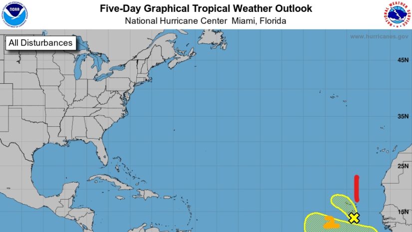
1. A small area of low pressure with some associated showers and thunderstorms are located about 100 miles south of Praia in the Cabo Verde Islands. Significant development of this system is not expected during the next day or two due to unfavorable upper-level winds and marginally warm waters. The low is forecast to move northward or north-northwestward through Thursday before the system moves over cool waters, ending development chances. Locally heavy rainfall and gusty winds are possible over portions of the Cabo Verde Islands through Wednesday.
2. A tropical wave is forecast to move off the west coast of Africa by late Thursday. This system has the potential for slow development over the far eastern Atlantic through the weekend while it moves westward at about 15 mph.
Persons at home and abroad are encouraged to download the DDM’s Alert app in the Apple App store or Google Play store to receive updates of any hazards affecting the Territory. You can also visit the DDM’s webpage at www.bviddm.com and subscribe for updates or like us on Facebook at www.facebook.com/bvi.ddm.
Disclaimer: The Department of Disaster Management (DDM) is not an official Meteorological Office. The Information disseminated by the Department is gathered from a number of professional sources used or contracted by the DDM to provide such information. This information is to be used as a guide by anyone who has interest in local weather conditions. By no means can DDM or the BVI Government be held accountable by anyone who uses this information appropriately for legal evidence or in justification of any decision which may result in the loss of finances, property or life.